IMAGES TAKEN NEAR TO
Jordanvale Avenue, GLASGOW, G14 0QU
Introduction
This page details the photographs taken nearby to Jordanvale Avenue, G14 0QU by members of the Geograph project.
The Geograph project started in 2005 with the aim of publishing, organising and preserving representative images for every square kilometre of Great Britain, Ireland and the Isle of Man.

There are currently over 7.5m images from over14,400 individuals and you can help contribute to the project by visiting https://www.geograph.org.uk
Image Map
Images are licensed for reuse under creativecommons.org/licenses/by-sa/2.0
Notes
- Clicking on the map will re-center to the selected point.
- The higher the marker number, the further away the image location is from the centre of the postcode.
Image Listing (86 Images Found)
Images are licensed for reuse under creativecommons.org/licenses/by-sa/2.0
Image
Details
Distance
1
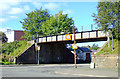
Old railway bridge
Crosses Squire Street at South Street. Part of the National Cycle Network, Route 7.
Image: © Thomas Nugent
Taken: 25 Sep 2010
0.05 miles
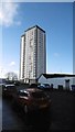
2
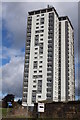
Curle Street Tower Block, Whiteinch, Glasgow
Image: © Leslie Barrie
Taken: 23 Aug 2014
0.06 miles
3
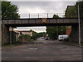
Looking up Squire Street
The railway bridge that crosses the south end of Squire Street, where it meets South Street, now carries a cycle path and is also seen in Image
Image: © Alec MacKinnon
Taken: 25 May 2014
0.06 miles
4
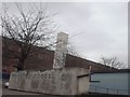
Whiteinch Cross
This can be quite a nice feature when its working.
Image: © Lynn M Reid
Taken: 26 Mar 2008
0.06 miles
5
64 Curle Street
Block of flats, Whiteinch
Image: © Richard Webb
Taken: 4 Jan 2016
0.06 miles
6
64 Curle Street
Entrance to a tower block.
Image: © Richard Webb
Taken: 4 Jan 2016
0.06 miles
7
Old railway line
Runs parallel to South Street, now part of the National Cycle Network, Route 7.
Image: © Thomas Nugent
Taken: 25 Sep 2010
0.07 miles
8
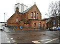
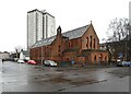
Former Whiteinch Jordanvale Parish Church and hall
Category B listed https://portal.historicenvironment.scot/apex/f?p=1505:300:::::VIEWTYPE,VIEWREF:designation,LB32282 former church, built in 1911 by P Macgregor Chalmers as Whiteinch Church to replace an earlier building dating from 1876/77, which had structural problems. The church was renamed Whiteinch Jordanvale Church at the union with the United Free Church in 1929. In 1981 the church united with Gordon Park Church, but continued to be used. A further union with Scotstoun Church in 1992 resulted in its closure. The building was sold and converted to housing.
The tower block behind is on Curle Street.
Image: © Richard Sutcliffe
Taken: 10 Feb 2025
0.07 miles
9
Former Whiteinch Jordanvale Parish Church and hall
Category B listed https://portal.historicenvironment.scot/apex/f?p=1505:300:::::VIEWTYPE,VIEWREF:designation,LB32282 former church, built in 1911 by P Macgregor Chalmers as Whiteinch Church to replace an earlier building dating from 1876/77, which had structural problems. The church was renamed Whiteinch Jordanvale Church at the union with the United Free Church in 1929. In 1981 the church united with Gordon Park Church, but continued to be used. A further union with Scotstoun Church in 1992 resulted in its closure. The building was sold and converted to housing.
The tower block behind is on Curle Street.
Image: © Richard Sutcliffe
Taken: 10 Feb 2025
0.08 miles
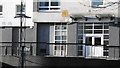
10
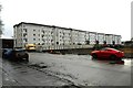
Southview Apartments
The flats on Curle Street were built in two phases. Those on the right were built around 2008; those on the left around 2023-2024.
Image: © Richard Sutcliffe
Taken: 10 Feb 2025
0.08 miles