IMAGES TAKEN NEAR TO
Lasswade Street, GLASGOW, G14 0PF
Introduction
This page details the photographs taken nearby to Lasswade Street, G14 0PF by members of the Geograph project.
The Geograph project started in 2005 with the aim of publishing, organising and preserving representative images for every square kilometre of Great Britain, Ireland and the Isle of Man.

There are currently over 7.5m images from over14,400 individuals and you can help contribute to the project by visiting https://www.geograph.org.uk
Image Map
Images are licensed for reuse under creativecommons.org/licenses/by-sa/2.0
Notes
- Clicking on the map will re-center to the selected point.
- The higher the marker number, the further away the image location is from the centre of the postcode.
Image Listing (162 Images Found)
Images are licensed for reuse under creativecommons.org/licenses/by-sa/2.0
Image
Details
Distance
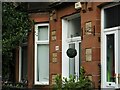
1
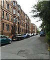
Lasswade Street
Red sandstone tenements.
Image: © Richard Sutcliffe
Taken: 1 Sep 2023
0.02 miles
2
Yoker Ferry railway station (site), Glasgow
Opened in 1896 as "Yoker" by the Lanarkshire and Dumbartonshire Railway, part of the Caledonian Railway, on the line from Partick to Dumbarton. The name was changed to "Yoker Ferry" in 1954. The station closed in 1964.
View south east towards Scotstoun West, Partick and Glasgow. The platform was partly extant and some vegetation clearance had recently taken place when this image was taken.
Image: © Nigel Thompson
Taken: 21 Feb 2019
0.03 miles
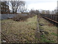
3
Remains of railway bridge
The bridge that used to cross over Greenlaw Road carried the Lanarkshire and Dumbartonshire railway, this part of which opened in 1896. The support is wide, as this was the location of Yoker (later Yoker Ferry) Station and there was an island platform and two lines above. The station closed in 1964, but the line continued in operation until 1978.
Workmen are busy digging a drainage channel behind the barriers.
Image: © Richard Sutcliffe
Taken: 1 Sep 2023
0.04 miles
4

USA Nails & Beauty Clyde
Nail and beauty salon on Dumbarton Road.
Image: © Richard Sutcliffe
Taken: 1 Sep 2023
0.04 miles
5

Clydeside Motor Factors
At the corner of Dumbarton Road and Bouverie Street.
Image: © Richard Sutcliffe
Taken: 1 Sep 2023
0.04 miles
6

Station Bar
At the corner of Dumbarton Road and Greenlaw Road. The station in question is probably the Yoker (later Yoker Ferry) Station of the Lanarkshire and Dumbartonshire Railway station Image, which was located just to the south. The current Yoker Station (on the former Glasgow Yoker and Clydebank Railway) is a few hundred metres to the northwest Image
Image: © Richard Sutcliffe
Taken: 1 Sep 2023
0.05 miles
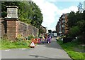
7

Cycle path
The joint footpath and cycle path follows the route of an old railway line. It leads to Scotstoun, Partick and Glasgow City Centre.
Image: © Richard Sutcliffe
Taken: 1 Sep 2023
0.05 miles
8

Station Bar
At the corner of Dumbarton Road and Greenlaw Road.
Image: © Richard Sutcliffe
Taken: 21 Jan 2022
0.05 miles
9
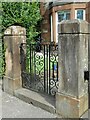
Wrought iron gate
A decorative gate and gate piers on a house on Dumbarton Road.
Image: © Richard Sutcliffe
Taken: 1 Sep 2023
0.06 miles
10
Architectural details
The architect has used both red and yellow sandstone in the front of these houses on Dumbarton Road.
Image: © Richard Sutcliffe
Taken: 1 Sep 2023
0.06 miles