IMAGES TAKEN NEAR TO
Ellerslie Crescent, GLASGOW, G14 0NY
Introduction
This page details the photographs taken nearby to Ellerslie Crescent, G14 0NY by members of the Geograph project.
The Geograph project started in 2005 with the aim of publishing, organising and preserving representative images for every square kilometre of Great Britain, Ireland and the Isle of Man.

There are currently over 7.5m images from over14,400 individuals and you can help contribute to the project by visiting https://www.geograph.org.uk
Image Map (Loading...)


Getting Data...Please wait
Leaflet Map data © OpenStreetMap
Images are licensed for reuse under creativecommons.org/licenses/by-sa/2.0
Notes
- Clicking on the map will re-center to the selected point.
- The higher the marker number, the further away the image location is from the centre of the postcode.
Image Listing (219 Images Found)
Images are licensed for reuse under creativecommons.org/licenses/by-sa/2.0
Image
Details
Distance
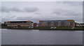
1
Ellerslie Path
Looking across the Clyde from Renfrew to houses and flats at Yoker.
Image: © M J Richardson
Taken: 19 May 2014
0.04 miles
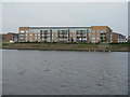
2
New flats by the Clyde
At Yoker, west of the Renfrew Ferry slipway.
Image: © Thomas Nugent
Taken: 29 Mar 2010
0.05 miles
3
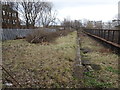
Yoker Ferry railway station (site), Glasgow
Opened in 1896 as "Yoker" by the Lanarkshire and Dumbartonshire Railway, part of the Caledonian Railway, on the line from Partick to Dumbarton. The name was changed to "Yoker Ferry" in 1954. The station closed in 1964.
View south east towards Scotstoun West, Partick and Glasgow. The platform was partly extant and some vegetation clearance had recently taken place when this image was taken.
Image: © Nigel Thompson
Taken: 21 Feb 2019
0.06 miles
4
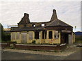
The Wharf Bar, Yoker
At least it used to be! I had no idea this pub lay in ruins until I came down here on my Geographing mission.
Image: © Stephen Sweeney
Taken: 17 Jun 2007
0.06 miles
5
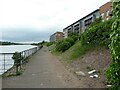
Clyde Walkway
Looking west from Yoker Ferry.
Image: © Richard Sutcliffe
Taken: 10 Jun 2021
0.06 miles
6
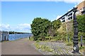
Millennium Milepost, Yoker, Glasgow
Cycle path by the River Clyde
Image: © Leslie Barrie
Taken: 23 Aug 2014
0.07 miles
7
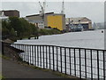
Pathway along the Clyde
Looking up river towards BAE Systems naval shipyard
Image: © Darrin Antrobus
Taken: 18 May 2007
0.07 miles
8

Cycle path
The joint footpath and cycle path follows the route of an old railway line. It leads to Scotstoun, Partick and Glasgow City Centre.
Image: © Richard Sutcliffe
Taken: 1 Sep 2023
0.08 miles
9
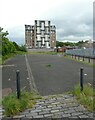
Scotland?s tallest timber building
Ellerslie Crescent is one of Scotland’s most advanced housing projects through its adoption of Cross Laminated Timber construction. It was the winner of the Affordable Housing Project of the Year in the Structural Timber Awards 2018 https://mastarchitects.co.uk/our-projects/ellerslie-crescent-yoker/.
Image: © Richard Sutcliffe
Taken: 10 Jun 2021
0.08 miles
10
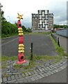
Scotland?s tallest timber building
Ellerslie Crescent is one of Scotland’s most advanced housing projects through its adoption of Cross Laminated Timber construction. It was the winner of the Affordable Housing Project of the Year in the Structural Timber Awards 2018 https://mastarchitects.co.uk/our-projects/ellerslie-crescent-yoker/.
In the foreground is a Millennium milepost on National Cycle Route 7.
Image: © Richard Sutcliffe
Taken: 10 Jun 2021
0.08 miles