IMAGES TAKEN NEAR TO
Dumbarton Road, GLASGOW, G14 0HZ
Introduction
This page details the photographs taken nearby to Dumbarton Road, G14 0HZ by members of the Geograph project.
The Geograph project started in 2005 with the aim of publishing, organising and preserving representative images for every square kilometre of Great Britain, Ireland and the Isle of Man.

There are currently over 7.5m images from over14,400 individuals and you can help contribute to the project by visiting https://www.geograph.org.uk
Image Map
Images are licensed for reuse under creativecommons.org/licenses/by-sa/2.0
Notes
- Clicking on the map will re-center to the selected point.
- The higher the marker number, the further away the image location is from the centre of the postcode.
Image Listing (68 Images Found)
Images are licensed for reuse under creativecommons.org/licenses/by-sa/2.0
Image
Details
Distance
1
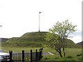
Blawart Hill
The area has been cleared of buildings, then at a later date a sculpted mound raised in a small glass strewn park.
Image: © Richard Webb
Taken: 9 May 2012
0.06 miles
2
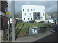
Plean Street Dental Clinic
View from the A814.
Image: © Barbara Carr
Taken: 18 Apr 2013
0.08 miles
4

HMS Defender (D36)
Under construction at BAE's Scotstoun shipyard.
Image: © Thomas Nugent
Taken: 29 Mar 2010
0.11 miles
5
Burnham Road, Scotstoun
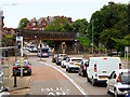
In the foreground is the parapet of the Caledonian Railway's Riverside line from Glasgow Central Low Level to Dumbarton, here crossing Burnham Road just west of the former Scotstoun West station, opened in 1896 and closed in 1964. In the middle distance, where Burnham Road meets Dumbarton Road and continues on as Anniesland Road towards the tower blocks at Scotstounhill, the long bridge diagonally over the crossroads was built in 1907 to take a goods branch line to Rothesay Dock, an expensive line to construct as it involved a number of other large bridges under and over roads and also under the Riverside line itself at Yoker Ferry station. It had to take an "inland" route as the land between the Riverside line and the river was fully occupied by shipyards and other engineering works. The route of the Riverside line has been obliterated by new housing development further west and the Glasgow to Loch Lomond cycleway, which follows the old railway from Partick, is deviated via the Rothesay Dock branch as far as Yoker.
Image: © A-M-Jervis
Taken: 15 Dec 2007
0.11 miles
6

easyJet plane approaching Glasgow
Approaching Glasgow Airport from the northeast, viewed from Braehead shopping centre. The towerblocks undergoing demolition are at Scotstoun.
Image: © Thomas Nugent
Taken: 11 Sep 2010
0.11 miles
7

Demolition at Scotstoun
Bold colours revealed for all to see.
Image: © Thomas Nugent
Taken: 11 Sep 2010
0.11 miles
8
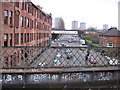
Disused Railway Bridge over Dumbarton Road
Image: © David Dixon
Taken: 2 Aug 2019
0.12 miles
9
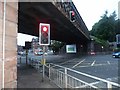
Dumbarton Road passes under a dismantled railway
A walkway now uses this rather massive bridge
Image: © Alan Reid
Taken: 9 Sep 2013
0.12 miles
10
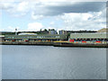
BAE Systems Scotstoun shipyard
Opposite Xscape at Braehead on the Upper Clyde.
Image: © Thomas Nugent
Taken: 2 Aug 2013
0.12 miles