IMAGES TAKEN NEAR TO
Methil Street, GLASGOW, G14 0AA
Introduction
This page details the photographs taken nearby to Methil Street, G14 0AA by members of the Geograph project.
The Geograph project started in 2005 with the aim of publishing, organising and preserving representative images for every square kilometre of Great Britain, Ireland and the Isle of Man.

There are currently over 7.5m images from over14,400 individuals and you can help contribute to the project by visiting https://www.geograph.org.uk
Image Map
Images are licensed for reuse under creativecommons.org/licenses/by-sa/2.0
Notes
- Clicking on the map will re-center to the selected point.
- The higher the marker number, the further away the image location is from the centre of the postcode.
Image Listing (39 Images Found)
Images are licensed for reuse under creativecommons.org/licenses/by-sa/2.0
Image
Details
Distance
1
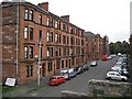
Henrietta Street
Sandstone tenements seen from the disused railway which is now part of the National Cycle Network (Route 7).
Image: © Richard Webb
Taken: 26 Sep 2009
0.04 miles
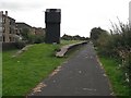
2
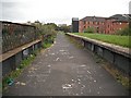
Victoria Park/ Scotstoun Station
An island platform which was accessed by stairs from the street below. Now the Lanarkshire and Dunbartonshire Railway trackbed is a cycle path (National Cycle Network route 7.)
Image: © Richard Webb
Taken: 26 Sep 2009
0.06 miles
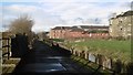
3

The end of Lennox Avenue on a frosty December morning
Image: © Alpin Stewart
Taken: 27 Dec 2017
0.06 miles
4
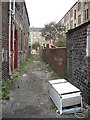
Lane off Dumbarton Road
Lane behind tenements.
Image: © Richard Webb
Taken: 26 Sep 2009
0.06 miles
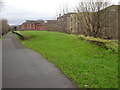
5
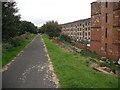
Lanarkshire and Dunbartonshire Railway
Now dismantled and used as a cycle path (Route 7, National Cycle Network). Running behind the tenements on Earl Street.
Image: © Richard Webb
Taken: 26 Sep 2009
0.06 miles
6
Whiteinch Riverside Station
An island platform which was accessed by stairs from the street below. Now the Lanarkshire and Dunbartonshire Railway trackbed is a cycle path (National Cycle Network route 7.)
Image: © Richard Webb
Taken: 26 Sep 2009
0.06 miles
7
Scotstoun East Station
Site of a railway station on the Lanarkshire and Dunbartonshire Railway, now a cycle track.
Image: © Richard Webb
Taken: 4 Jan 2016
0.07 miles
8
Whiteinch Riverside
Former railway station on the Lanarkshire and Dunbartonshire Railway. The platform was an island platform, accessed by stairs under the bridge.
Image: © Richard Webb
Taken: 26 Sep 2009
0.07 miles
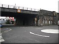
9
Scotstoun East railway station (site), Glasgow
Opened in 1896 as "Victoria Park" by the Lanarkshire and Dumbartonshire Railway, effectively part of the Caledonian Railway, on the line from Partick to Dumbarton. The name was changed to "Scotstoun" in 1900, and "Scotstoun East" in 1952. The station closed in 1964.
View north west towards Scotstoun West and Dumbarton. Both the platform on the viaduct and the former entrance down below at street level were both extant when this image was taken.
Image: © Nigel Thompson
Taken: 21 Feb 2019
0.08 miles
10
Industrial site, Scotstoun
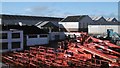
Off South Street, view from the site of Scotstoun East railway station.
Image: © Richard Webb
Taken: 4 Jan 2016
0.09 miles