IMAGES TAKEN NEAR TO
Kelso Street, G13 4BT
Introduction
This page details the photographs taken nearby to Kelso Street, G13 4BT by members of the Geograph project.
The Geograph project started in 2005 with the aim of publishing, organising and preserving representative images for every square kilometre of Great Britain, Ireland and the Isle of Man.

There are currently over 7.5m images from over14,400 individuals and you can help contribute to the project by visiting https://www.geograph.org.uk
Image Map
Images are licensed for reuse under creativecommons.org/licenses/by-sa/2.0
Notes
- Clicking on the map will re-center to the selected point.
- The higher the marker number, the further away the image location is from the centre of the postcode.
Image Listing (15 Images Found)
Images are licensed for reuse under creativecommons.org/licenses/by-sa/2.0
Image
Details
Distance
1
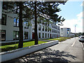
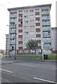
Kelso Street, Yoker
New apartment buildings on the site of the former Garscadden Primary School.
Image: © Thomas Nugent
Taken: 20 Aug 2022
0.03 miles
2
St Brendan's Roman Catholic Church
On Kelso Street.
Image: © Richard Sutcliffe
Taken: 14 Jul 2016
0.04 miles
3
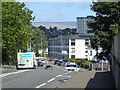
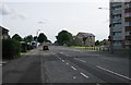
Kelso Street
Looking north from the railway bridge.
Image: © Thomas Nugent
Taken: 20 Aug 2022
0.04 miles
4
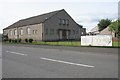
St Brendan's Roman Catholic Church Hall
Beside Halley Street.
Image: © Richard Sutcliffe
Taken: 14 Jul 2016
0.07 miles
6
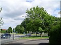
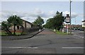
Roundabout at Kelso Street and Alderman Road
In Yoker.
Image: © Stephen Sweeney
Taken: 15 Jun 2008
0.16 miles
8
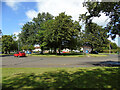
Roundabout on Alderman Road
At the junction with Kelso Street.
Image: © Thomas Nugent
Taken: 20 Aug 2022
0.18 miles
9
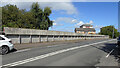
Railway bridge at Kelso Street
The bridge carries Kelso Street over the Argyle and North Clyde lines as well as the lines that connect the two halves of Yoker Depot.
Image: © Thomas Nugent
Taken: 20 Aug 2022
0.20 miles
10
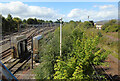
Yoker railway depot
Looking into the west end of the depot from the Kelso Street bridge. The line on the right is the Argyle/North Clyde line.
Image: © Thomas Nugent
Taken: 20 Aug 2022
0.21 miles