IMAGES TAKEN NEAR TO
Archerhill Road, GLASGOW, G13 3NW
Introduction
This page details the photographs taken nearby to Archerhill Road, G13 3NW by members of the Geograph project.
The Geograph project started in 2005 with the aim of publishing, organising and preserving representative images for every square kilometre of Great Britain, Ireland and the Isle of Man.

There are currently over 7.5m images from over14,400 individuals and you can help contribute to the project by visiting https://www.geograph.org.uk
Image Map
Images are licensed for reuse under creativecommons.org/licenses/by-sa/2.0
Notes
- Clicking on the map will re-center to the selected point.
- The higher the marker number, the further away the image location is from the centre of the postcode.
Image Listing (47 Images Found)
Images are licensed for reuse under creativecommons.org/licenses/by-sa/2.0
Image
Details
Distance
2
A82, Great Western Road at Knightswood
Image: © Elliott Simpson
Taken: 14 May 2016
0.12 miles
3
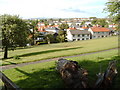
Knightswood St Margaret's Parish Church spire
Almost time to go!
Image: © Alan Reid
Taken: 1 Apr 2017
0.12 miles
4
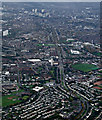
Great Western Road from the air
Knightswood Cross is in the foreground, Anniesland Cross can be seen nearer the centre. The decommissioned Kelvindale gas holders can be seen on the left. Gartnavel Hospitals campus is on the right. Anniesland Court towerblock is near the centre.
Image: © Thomas Nugent
Taken: 21 Oct 2013
0.12 miles
5
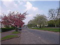
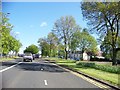
A82, Great Western Road
Passing through Knightswood, plenty blossom at this time.
Image: © wfmillar
Taken: 19 Apr 2011
0.12 miles
8
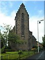
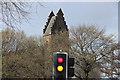
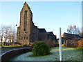
St Margaret's Church
The distinctive tall saddle-back tower at the eastern end of the church. St Margaret's Church dates from 1931 and is category B listed http://portal.historicenvironment.scot/designation/LB32274.
Image: © Richard Sutcliffe
Taken: 26 May 2022
0.12 miles
9
St Margaret's Church
At Knightswood Cross. Category B Listed http://portal.historicenvironment.scot/designation/LB32274 .
Image: © Thomas Nugent
Taken: 31 Dec 2019
0.12 miles
10

St Margaret's Church
The distinctive tall saddle-back tower, seen from beside St Ninian's RC Church. St Margaret's Church dates from 1931 and is category B listed http://portal.historicenvironment.scot/designation/LB32274.
Image: © Richard Sutcliffe
Taken: 26 May 2022
0.13 miles