IMAGES TAKEN NEAR TO
Pikeman Road, GLASGOW, G13 3BL
Introduction
This page details the photographs taken nearby to Pikeman Road, G13 3BL by members of the Geograph project.
The Geograph project started in 2005 with the aim of publishing, organising and preserving representative images for every square kilometre of Great Britain, Ireland and the Isle of Man.

There are currently over 7.5m images from over14,400 individuals and you can help contribute to the project by visiting https://www.geograph.org.uk
Image Map
Images are licensed for reuse under creativecommons.org/licenses/by-sa/2.0
Notes
- Clicking on the map will re-center to the selected point.
- The higher the marker number, the further away the image location is from the centre of the postcode.
Image Listing (20 Images Found)
Images are licensed for reuse under creativecommons.org/licenses/by-sa/2.0
Image
Details
Distance
1
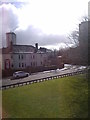
View from the Knightswood Community Centre
Image: © Elliott Simpson
Taken: 9 Mar 2019
0.13 miles
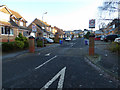
2
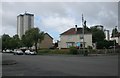
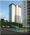
Junction of Lincoln Avenue and Alderman Road
The tower blocks are off Kirkton Avenue.
Image: © Richard Sutcliffe
Taken: 15 Aug 2017
0.14 miles
3

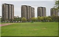
Tower blocks on Kestrel Road
There were a total of six tower blocks on Kestrel Road, off Lincoln Avenue, but two of the blocks have since been demolished, just leaving these four. Seen from Knightswood Park.
Image: © Richard Sutcliffe
Taken: 15 Aug 2017
0.17 miles
4
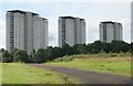
Tower blocks on Kestrel Road
There were a total of six tower blocks on Kestrel Road, off Lincoln Avenue, but two of the blocks have since been demolished, just leaving these four. Seen from Knightswood Park.
Image: © Richard Sutcliffe
Taken: 15 Aug 2017
0.17 miles
5
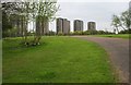
Tower blocks, Kestrel Road
Six tower blocks on Kestrel Road, off Lincoln Avenue, The two blocks on the left have since been demolished.
Image: © Richard Sutcliffe
Taken: 4 May 2006
0.17 miles
6
Tower blocks, Kestrel Road
There were a total of six tower blocks on Kestrel Road, off Lincoln Avenue, five of which can be seen here. Two of the blocks have since been demolished.
Image: © Richard Sutcliffe
Taken: 4 May 2006
0.17 miles
8
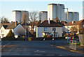
Alderman Road
The Lincoln Avenue towerblocks are in the background.
Image: © Thomas Nugent
Taken: 31 Dec 2019
0.20 miles
10
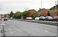
Laurel Park Gardens
A housing estate off Anniesland Road.
Image: © Thomas Nugent
Taken: 31 Dec 2019
0.21 miles