IMAGES TAKEN NEAR TO
Knightsbridge Street, GLASGOW, G13 2YN
Introduction
This page details the photographs taken nearby to Knightsbridge Street, G13 2YN by members of the Geograph project.
The Geograph project started in 2005 with the aim of publishing, organising and preserving representative images for every square kilometre of Great Britain, Ireland and the Isle of Man.

There are currently over 7.5m images from over14,400 individuals and you can help contribute to the project by visiting https://www.geograph.org.uk
Image Map
Images are licensed for reuse under creativecommons.org/licenses/by-sa/2.0
Notes
- Clicking on the map will re-center to the selected point.
- The higher the marker number, the further away the image location is from the centre of the postcode.
Image Listing (46 Images Found)
Images are licensed for reuse under creativecommons.org/licenses/by-sa/2.0
Image
Details
Distance
1
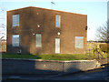
Boarded-up house on Knightswood Road
Within the Knightswood Secondary School grounds, so perhaps a former janitors' house.
Image: © Thomas Nugent
Taken: 31 Dec 2019
0.11 miles
2
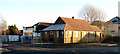
Gospel hall on Saxon Road
At the corner of Knightswood Road. See also Image
Image: © Thomas Nugent
Taken: 31 Dec 2019
0.11 miles
3
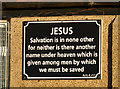
Gospel hall sign on Saxon Road
At the corner of Knightswood Road. See also Image
Image: © Thomas Nugent
Taken: 31 Dec 2019
0.11 miles
4
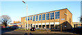
Knightswood Secondary School
On Knightswood Road. Designed by Gillespie, Kidd & Coia. Category B Listed http://portal.historicenvironment.scot/designation/LB43037 .
Image: © Thomas Nugent
Taken: 31 Dec 2019
0.11 miles
5
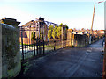
Knightswood Hospital gates
The hospital is long gone, but these gates on Knightswood Road survive.
Image: © Thomas Nugent
Taken: 31 Dec 2019
0.12 miles
6

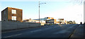
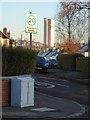
Knightswood Road
Looking towards the churches at Knightswood Cross.
Image: © Thomas Nugent
Taken: 31 Dec 2019
0.12 miles
7
Warden Road
With Anniesland Court in the distance.
Image: © Thomas Nugent
Taken: 31 Dec 2019
0.13 miles
8
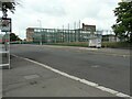
Knightswood Secondary School
On Knightswood Road. Designed by Gillespie, Kidd & Coia. Category B Listed http://portal.historicenvironment.scot/designation/LB43037 .
Image: © Thomas Nugent
Taken: 31 Dec 2019
0.13 miles
9
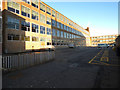
Knightswood Secondary School
The east wing of the Category B listed http://portal.historicenvironment.scot/designation/LB43037 school, which opened in 1958.
Image: © Richard Sutcliffe
Taken: 12 Jul 2021
0.14 miles
10
Knightswood Secondary School
On Knightswood Road. Designed by Gillespie, Kidd & Coia. Category B Listed http://portal.historicenvironment.scot/designation/LB43037 .
Image: © Thomas Nugent
Taken: 31 Dec 2019
0.14 miles