IMAGES TAKEN NEAR TO
Knightswood Road, GLASGOW, G13 2XF
Introduction
This page details the photographs taken nearby to Knightswood Road, G13 2XF by members of the Geograph project.
The Geograph project started in 2005 with the aim of publishing, organising and preserving representative images for every square kilometre of Great Britain, Ireland and the Isle of Man.

There are currently over 7.5m images from over14,400 individuals and you can help contribute to the project by visiting https://www.geograph.org.uk
Image Map
Images are licensed for reuse under creativecommons.org/licenses/by-sa/2.0
Notes
- Clicking on the map will re-center to the selected point.
- The higher the marker number, the further away the image location is from the centre of the postcode.
Image Listing (28 Images Found)
Images are licensed for reuse under creativecommons.org/licenses/by-sa/2.0
Image
Details
Distance
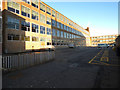
1
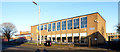
Knightswood Secondary School
On Knightswood Road. Designed by Gillespie, Kidd & Coia. Category B Listed http://portal.historicenvironment.scot/designation/LB43037 .
Image: © Thomas Nugent
Taken: 31 Dec 2019
0.03 miles
2
Knightswood Secondary School
On Knightswood Road. Designed by Gillespie, Kidd & Coia. Category B Listed http://portal.historicenvironment.scot/designation/LB43037 .
Image: © Thomas Nugent
Taken: 31 Dec 2019
0.04 miles
3
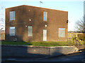
Boarded-up house on Knightswood Road
Within the Knightswood Secondary School grounds, so perhaps a former janitors' house.
Image: © Thomas Nugent
Taken: 31 Dec 2019
0.05 miles
4
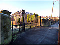
Knightswood Hospital gates
The hospital is long gone, but these gates on Knightswood Road survive.
Image: © Thomas Nugent
Taken: 31 Dec 2019
0.06 miles
5
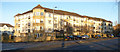
Flats on Anniesland Road
Modern flats on the north side of the street, opposite Knightswood fire station.
Image: © Thomas Nugent
Taken: 31 Dec 2019
0.07 miles
6
Knightswood Secondary School
On Knightswood Road. Designed by Gillespie, Kidd & Coia. Category B Listed http://portal.historicenvironment.scot/designation/LB43037 .
Image: © Thomas Nugent
Taken: 31 Dec 2019
0.08 miles
7
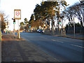
Anniesland Road
The traffic lights at Knightswood Road.
Image: © Thomas Nugent
Taken: 31 Dec 2019
0.09 miles
8
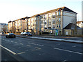
Flats on Anniesland Road
Modern flats on the north side of the street, near Knightswood fire station.
Image: © Thomas Nugent
Taken: 31 Dec 2019
0.09 miles
9
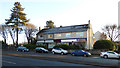
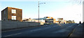
Businesses on Anniesland Road
Between Ryvra Road and Knightswood Road.
Image: © Thomas Nugent
Taken: 31 Dec 2019
0.10 miles
10
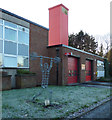
Knightswood Fire Station
The Commonwealth Games legacy sculpture is one of series created by prisoners at HMP Barlinnie which were installed in each of the city’s 11 stations at the time of the 2014 games.
Image: © Thomas Nugent
Taken: 31 Dec 2019
0.10 miles