IMAGES TAKEN NEAR TO
Friarscourt Avenue, GLASGOW, G13 2LF
Introduction
This page details the photographs taken nearby to Friarscourt Avenue, G13 2LF by members of the Geograph project.
The Geograph project started in 2005 with the aim of publishing, organising and preserving representative images for every square kilometre of Great Britain, Ireland and the Isle of Man.

There are currently over 7.5m images from over14,400 individuals and you can help contribute to the project by visiting https://www.geograph.org.uk
Image Map
Images are licensed for reuse under creativecommons.org/licenses/by-sa/2.0
Notes
- Clicking on the map will re-center to the selected point.
- The higher the marker number, the further away the image location is from the centre of the postcode.
Image Listing (24 Images Found)
Images are licensed for reuse under creativecommons.org/licenses/by-sa/2.0
Image
Details
Distance
1

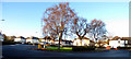
1930s Garden City style housing, Palmer Avenue
Image: © Rosalind Mitchell
Taken: 16 Jan 2022
0.16 miles
2
Roundabout at Cowdenhill Road
Viewed from Kingscliffe Avenue.
Image: © Thomas Nugent
Taken: 31 Dec 2019
0.17 miles
3
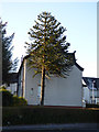
Monkey Puzzle tree
Araucaria araucana in a private garden by the roundabout at Cowdenhill Road and Knightscliffe Avenue.
Image: © Thomas Nugent
Taken: 31 Dec 2019
0.17 miles
4

Roundabout at Cowdenhill Road
At the junction with Knightscliffe Avenue.
Image: © Thomas Nugent
Taken: 31 Dec 2019
0.17 miles
5
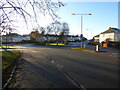
Cowdenhill Road
The roundabout at Kingscliffe Avenue.
Image: © Thomas Nugent
Taken: 31 Dec 2019
0.17 miles

7
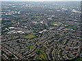
Knightswood and Glasgow from the air
The A82 Great Western Road can be seen heading towards the city centre.
Image: © Thomas Nugent
Taken: 14 Sep 2015
0.18 miles
8

Cottage flats, Cloberhill Road
Characteristically Scottish housing format: a block of four flats, 2-up, 2-down, with doors at the front and side.
Image: © Rosalind Mitchell
Taken: 16 Jan 2022
0.19 miles
9

All Tots Nursery, Great Western Road
Housed in the former Holy Cross Episcopal Church, Knightswood. The church was founded in 1926, but closed in 2013 when the congregation dropped below a sustainable number.
Image: © Richard Sutcliffe
Taken: 22 Feb 2019
0.20 miles
10

Postbox in the hedge, Baldwin Avenue
A few months before this picture was taken, the box was overgrown with brambles. These have since been cleared.
Image: © Rosalind Mitchell
Taken: 16 Jan 2022
0.20 miles