IMAGES TAKEN NEAR TO
Curfew Road, GLASGOW, G13 2JW
Introduction
This page details the photographs taken nearby to Curfew Road, G13 2JW by members of the Geograph project.
The Geograph project started in 2005 with the aim of publishing, organising and preserving representative images for every square kilometre of Great Britain, Ireland and the Isle of Man.

There are currently over 7.5m images from over14,400 individuals and you can help contribute to the project by visiting https://www.geograph.org.uk
Image Map
Images are licensed for reuse under creativecommons.org/licenses/by-sa/2.0
Notes
- Clicking on the map will re-center to the selected point.
- The higher the marker number, the further away the image location is from the centre of the postcode.
Image Listing (119 Images Found)
Images are licensed for reuse under creativecommons.org/licenses/by-sa/2.0
Image
Details
Distance
1
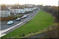
Rotherwood Avenue
Looking west from the footpath leading to the bridge over the Forth and Clyde Canal.
Image: © Richard Sutcliffe
Taken: 26 Jan 2017
0.02 miles
3
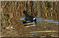
Moorhen in the Forth and Clyde Canal at Westerton
Near Westerton footbridge.
Image: © Thomas Nugent
Taken: 31 Dec 2019
0.08 miles
4
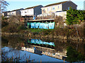
Forth and Clyde Canal at Westerton
Houses on Orchy Crescent overlooking the canal.
Image: © Thomas Nugent
Taken: 31 Dec 2019
0.08 miles
5
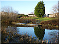
The Forth and Clyde Canal at Westerton
A pontoon by a small park near Westerton footbridge and railway station.
Image: © Thomas Nugent
Taken: 31 Dec 2019
0.09 miles
6
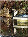
Cormorant by the Forth and Clyde Canal at Westerton
Resting on the pontoon near Westerton railway station.
Image: © Thomas Nugent
Taken: 31 Dec 2019
0.09 miles
7
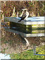
Cormorant by the Forth and Clyde Canal at Westerton
On the pontoon near Westerton railway station.
Image: © Thomas Nugent
Taken: 31 Dec 2019
0.09 miles
8
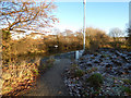
Path near the Forth and Clyde Canal
Between the canal and Rotherwood Avenue.
Image: © Thomas Nugent
Taken: 31 Dec 2019
0.10 miles
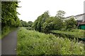
9
The Forth & Clyde Canal
Looking west from the footbridge near Westerton railway station.
Image: © Thomas Nugent
Taken: 12 Jul 2013
0.10 miles
10
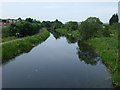
![Forth and Clyde Canal [56]](https://s1.geograph.org.uk/geophotos/06/25/03/6250313_86d6eaba_120x120.jpg)
Forth and Clyde Canal [56]
A view of the canal looking towards Bowling from the Westerton footbridge.
The Forth and Clyde Canal was completed in 1790 and it provided a route for vessels between the Firth of Forth and the Firth of Clyde at the narrowest part (35 miles, 56km) of the Scottish Lowlands. Closed in 1963, the canal became semi-derelict. Millennium funds were used to regenerate the canal. The main line of the canal is a Scheduled Monument with details at: http://portal.historicenvironment.scot/designation/SM6775
Image: © Michael Dibb
Taken: 25 Jun 2019
0.10 miles