IMAGES TAKEN NEAR TO
Towerhill Road, GLASGOW, G13 2DE
Introduction
This page details the photographs taken nearby to Towerhill Road, G13 2DE by members of the Geograph project.
The Geograph project started in 2005 with the aim of publishing, organising and preserving representative images for every square kilometre of Great Britain, Ireland and the Isle of Man.

There are currently over 7.5m images from over14,400 individuals and you can help contribute to the project by visiting https://www.geograph.org.uk
Image Map
Images are licensed for reuse under creativecommons.org/licenses/by-sa/2.0
Notes
- Clicking on the map will re-center to the selected point.
- The higher the marker number, the further away the image location is from the centre of the postcode.
Image Listing (52 Images Found)
Images are licensed for reuse under creativecommons.org/licenses/by-sa/2.0
Image
Details
Distance
1

Towerglaive Park, High Knightswood
An open space between the culs-de-sac Glaive Road and Towerhill Road. The name is rather contrived; a glaive is a particularly nastly kind of medieval polearm and a tower is, well, a tower.
Street names in Knightswood are drawn from the works of Walter Scott.
Image: © Rosalind Mitchell
Taken: 16 Jan 2022
0.11 miles
2
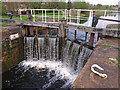
Forth and Clyde Canal
Lock 31 at Blairdardie.
Image: © wfmillar
Taken: 19 Apr 2011
0.12 miles
3

Trinley Brae
The path leads from Blairdardie Road to Mace Road at the top of the slope. Trinley Brae is one of the many parks in Glasgow. The sign in the foreground explains that the area is a wildlife haven, and is managed for wildlife.
Image: © Richard Sutcliffe
Taken: 22 Feb 2019
0.13 miles
4
Lock No 31, Clobberhill
On the Forth & Clyde Canal at Blairdardie.
Image: © Gordon Brown
Taken: 24 Jul 2017
0.13 miles
5
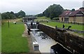
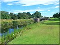
Forth and Clyde canal
Locks at Blairdardie
Image: © Alan Reid
Taken: 12 Sep 2013
0.14 miles
6

Trinley Brae
The paths lead from Blairdardie Road to Mace Road at the top of the slope. Trinley Brae is one of the many parks in Glasgow. The sign in the foreground explains that the area is a wildlife haven, and is managed for wildlife.
Image: © Richard Sutcliffe
Taken: 22 Feb 2019
0.15 miles
7
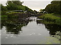
Lock gate on Forth and Clyde Canal
Between Drumchapel and Blairdardie.
Image: © Stephen Sweeney
Taken: 9 Aug 2007
0.15 miles
8

Ho's Authentic Chinese Cuisine
Chinese restaurant and takeaway on Rotherwood Avenue.
Image: © Richard Sutcliffe
Taken: 22 Feb 2019
0.16 miles

10
Blairdardie Road
The Monkey Puzzle tree seems a bit out of place.
Image: © Richard Sutcliffe
Taken: 22 Feb 2019
0.16 miles