IMAGES TAKEN NEAR TO
Knightswood Road, GLASGOW, G13 2BU
Introduction
This page details the photographs taken nearby to Knightswood Road, G13 2BU by members of the Geograph project.
The Geograph project started in 2005 with the aim of publishing, organising and preserving representative images for every square kilometre of Great Britain, Ireland and the Isle of Man.

There are currently over 7.5m images from over14,400 individuals and you can help contribute to the project by visiting https://www.geograph.org.uk
Image Map
Images are licensed for reuse under creativecommons.org/licenses/by-sa/2.0
Notes
- Clicking on the map will re-center to the selected point.
- The higher the marker number, the further away the image location is from the centre of the postcode.
Image Listing (53 Images Found)
Images are licensed for reuse under creativecommons.org/licenses/by-sa/2.0
Image
Details
Distance
1

Trinley Brae
Trinley Brae is one of the many parks in Glasgow. The area is a wildlife haven, and is managed for wildlife.
Image: © Richard Sutcliffe
Taken: 22 Feb 2019
0.11 miles
2

Trinley Brae
The path leads from Blairdardie Road to Mace Road at the top of the slope. Trinley Brae is one of the many parks in Glasgow. The sign in the foreground explains that the area is a wildlife haven, and is managed for wildlife.
Image: © Richard Sutcliffe
Taken: 22 Feb 2019
0.11 miles
3

Trinley Brae
The paths lead from Blairdardie Road to Mace Road at the top of the slope. Trinley Brae is one of the many parks in Glasgow. The sign in the foreground explains that the area is a wildlife haven, and is managed for wildlife.
Image: © Richard Sutcliffe
Taken: 22 Feb 2019
0.12 miles
4

Towerglaive Park, High Knightswood
An open space between the culs-de-sac Glaive Road and Towerhill Road. The name is rather contrived; a glaive is a particularly nastly kind of medieval polearm and a tower is, well, a tower.
Street names in Knightswood are drawn from the works of Walter Scott.
Image: © Rosalind Mitchell
Taken: 16 Jan 2022
0.12 miles


7

1930s Garden City style housing, Palmer Avenue
Image: © Rosalind Mitchell
Taken: 16 Jan 2022
0.15 miles
8

Knightswood Church
The United Free Church of Scotland seen from the corner of Blairdardie Street and Turret Road.
Image: © Richard Sutcliffe
Taken: 22 Feb 2019
0.16 miles
9
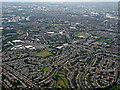
Knightswood and Glasgow from the air
The A82 Great Western Road can be seen heading towards the city centre.
Image: © Thomas Nugent
Taken: 14 Sep 2015
0.16 miles
10

Knightswood Church
United Free Church of Scotland on Great Western Road. The sign advertises services on Sundays at 11.00am and a free drop-in cafe between 1pm and 2pm on Wednesdays.
Image: © Richard Sutcliffe
Taken: 22 Feb 2019
0.16 miles