IMAGES TAKEN NEAR TO
Bearsden Road, GLASGOW, G13 1YL
Introduction
This page details the photographs taken nearby to Bearsden Road, G13 1YL by members of the Geograph project.
The Geograph project started in 2005 with the aim of publishing, organising and preserving representative images for every square kilometre of Great Britain, Ireland and the Isle of Man.

There are currently over 7.5m images from over14,400 individuals and you can help contribute to the project by visiting https://www.geograph.org.uk
Image Map
Images are licensed for reuse under creativecommons.org/licenses/by-sa/2.0
Notes
- Clicking on the map will re-center to the selected point.
- The higher the marker number, the further away the image location is from the centre of the postcode.
Image Listing (119 Images Found)
Images are licensed for reuse under creativecommons.org/licenses/by-sa/2.0
Image
Details
Distance
1
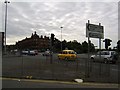
Morning traffic on Anniesland Cross
Approximately 9am on a Thursday morning.
Image: © Stephen Sweeney
Taken: 9 Aug 2007
0.05 miles
2
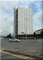
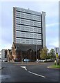
Anniesland Court
The 22-storey tower block dates from 1966-8 and is Category A listed http://portal.historicenvironment.scot/designation/LB43034. It dominates the area around Anniesland Cross.
Image: © Richard Sutcliffe
Taken: 12 Jul 2021
0.05 miles
3
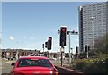
Traffic lights at Great Western Road Anniesland
From A739 looking north
Image: © John Firth
Taken: 17 May 2013
0.06 miles
4
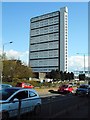
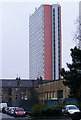
Anniesland Court
Category A listed [http://portal.historicenvironment.scot/designation/LB43034] 22 storey tower block, built in 1966-68. Seen from across the A739 Bearsden Road.
Image: © Richard Sutcliffe
Taken: 27 Apr 2018
0.06 miles
5
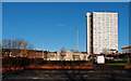
Anniesland Court and Temple Anniesland Parish Church
The Category A listed https://portal.historicenvironment.scot/designation/LB43034 22-storey tower block looms over the Category B listed https://portal.historicenvironment.scot/designation/LB43035 Church of Scotland buildings.
Image: © Richard Sutcliffe
Taken: 13 Oct 2023
0.06 miles
6
Anniesland Court
Viewed from Foulis Lane, near Anniesland railway station.
One of only 51 Post WWII Category A Listed buildings in Scotland http://portal.historicenvironment.scot/designation/LB43034 .
Image: © Thomas Nugent
Taken: 5 Apr 2011
0.06 miles
7
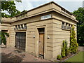
Old Toilet Block, Anniesland, Glasgow
Just behind the hedge the Grade 'C' listed building is undergoing renovation to become restaurant. Anniesland tower block to the right behind.
Image: © wfmillar
Taken: 22 Nov 2011
0.06 miles
8
Public conveniences, Anniesland Cross
Category C listed http://portal.historicenvironment.scot/designation/LB43033 public conveniences, dating from 1938. Today they appear rather isolated within the complex modern junction at Anniesland Cross, but when built they were in a more prominent position at the junction of Anniesland Road and Great Western Road. They are currently closed and barriers are erected around the building, suggesting some work is being undertaken on them.
Image: © Richard Sutcliffe
Taken: 12 Jul 2021
0.06 miles
9
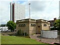
Public conveniences, Anniesland Cross
Category C listed http://portal.historicenvironment.scot/designation/LB43033 public conveniences, dating from 1938. Today they appear rather isolated within the complex modern junction at Anniesland Cross, but when built they were in a more prominent position at the junction of Anniesland Road and Great Western Road. They are currently closed and barriers are erected around the building, suggesting some work is being undertaken on them.
In the background is Anniesland Court, a 22-storey tower block built in 1966-8 and Category A listed http://portal.historicenvironment.scot/designation/LB43034.
Image: © Richard Sutcliffe
Taken: 12 Jul 2021
0.06 miles
10
Anniesland Court near Annisland Junction
View from Crow Road. This tower block is 'A' listed and a popular place to live.
Image: © wfmillar
Taken: 22 Nov 2011
0.07 miles