IMAGES TAKEN NEAR TO
Jordanhill Drive, GLASGOW, G13 1UW
Introduction
This page details the photographs taken nearby to Jordanhill Drive, G13 1UW by members of the Geograph project.
The Geograph project started in 2005 with the aim of publishing, organising and preserving representative images for every square kilometre of Great Britain, Ireland and the Isle of Man.

There are currently over 7.5m images from over14,400 individuals and you can help contribute to the project by visiting https://www.geograph.org.uk
Image Map
Images are licensed for reuse under creativecommons.org/licenses/by-sa/2.0
Notes
- Clicking on the map will re-center to the selected point.
- The higher the marker number, the further away the image location is from the centre of the postcode.
Image Listing (37 Images Found)
Images are licensed for reuse under creativecommons.org/licenses/by-sa/2.0
Image
Details
Distance
1
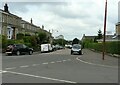
Jordanhill Drive
Seen from the junction with Seggielea Road.
Image: © Richard Sutcliffe
Taken: 12 Jul 2021
0.05 miles
2
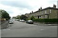
Seggielea Road
Seen from the junction with Helensburgh Drive.
Image: © Richard Sutcliffe
Taken: 12 Jul 2021
0.07 miles
3
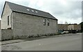
Rear of new building
The rear of part of a new development (Jordanhill Park) beside Jordanhill Drive.
Image: © Richard Sutcliffe
Taken: 12 Jul 2021
0.08 miles
4
Crawfurd Building, Jordanhill
Originally home to the Speech & Drama Department at Jordanhill College of Education, the college itself ceased to exist after being transferred to Strathclyde University to become its 'Jordanhill Campus'.
Image: © Raymond Okonski
Taken: 19 Oct 2007
0.10 miles
5
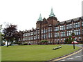
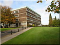
University of Strathclyde, Jordanhill campus
Image: © Darrin Antrobus
Taken: 27 Jun 2007
0.13 miles
6
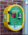
Defibrillator at Knightswood Fire Station
On the front wall of the fire station on Anniesland Road Image
Image: © Thomas Nugent
Taken: 31 Dec 2019
0.14 miles
7
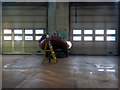
Knightswood Fire Station
A RHIB on a trailer inside the fire station, viewed through a front door window.
Image: © Thomas Nugent
Taken: 31 Dec 2019
0.14 miles
8

Entrance to Anniesland Bowling and Tennis Club
A narrow driveway leads between houses from Helensburgh Drive to the club grounds, which are surrounded by residential properties.
Image: © Richard Sutcliffe
Taken: 12 Jul 2021
0.14 miles
9
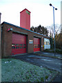
Knightswood Fire Station
On Anniesland Road. Note the defibrillator on the wall Image
Image: © Thomas Nugent
Taken: 31 Dec 2019
0.15 miles
10
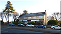
Businesses on Anniesland Road
Between Ryvra Road and Knightswood Road.
Image: © Thomas Nugent
Taken: 31 Dec 2019
0.15 miles