IMAGES TAKEN NEAR TO
Hallydown Drive, GLASGOW, G13 1UF
Introduction
This page details the photographs taken nearby to Hallydown Drive, G13 1UF by members of the Geograph project.
The Geograph project started in 2005 with the aim of publishing, organising and preserving representative images for every square kilometre of Great Britain, Ireland and the Isle of Man.

There are currently over 7.5m images from over14,400 individuals and you can help contribute to the project by visiting https://www.geograph.org.uk
Image Map (Loading...)


Getting Data...Please wait
Leaflet Map data © OpenStreetMap
Images are licensed for reuse under creativecommons.org/licenses/by-sa/2.0
Notes
- Clicking on the map will re-center to the selected point.
- The higher the marker number, the further away the image location is from the centre of the postcode.
Image Listing (27 Images Found)
Images are licensed for reuse under creativecommons.org/licenses/by-sa/2.0
Image
Details
Distance
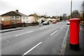
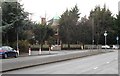
2
Southbrae Drive
Tree lined street after heavy rain.
Image: © Richard Webb
Taken: 19 Jan 2014
0.13 miles
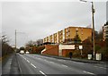
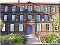
5
Tower Dene
A Category C listed house http://portal.historicenvironment.scot/designation/LB32299 at the corner of Southbrae Drive and Anniesland Road, dating from 1900.
Image: © Richard Sutcliffe
Taken: 19 Dec 2019
0.16 miles
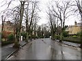
6
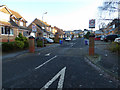
Laurel Park Gardens
A housing estate off Anniesland Road.
Image: © Thomas Nugent
Taken: 31 Dec 2019
0.16 miles
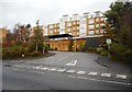
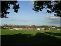
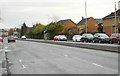
10
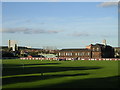
Playing fields at Jordanhill College
Evening light.
Image: © Chris Upson
Taken: 1 Sep 2005
0.17 miles