IMAGES TAKEN NEAR TO
Munro Road, GLASGOW, G13 1SH
Introduction
This page details the photographs taken nearby to Munro Road, G13 1SH by members of the Geograph project.
The Geograph project started in 2005 with the aim of publishing, organising and preserving representative images for every square kilometre of Great Britain, Ireland and the Isle of Man.

There are currently over 7.5m images from over14,400 individuals and you can help contribute to the project by visiting https://www.geograph.org.uk
Image Map
Images are licensed for reuse under creativecommons.org/licenses/by-sa/2.0
Notes
- Clicking on the map will re-center to the selected point.
- The higher the marker number, the further away the image location is from the centre of the postcode.
Image Listing (38 Images Found)
Images are licensed for reuse under creativecommons.org/licenses/by-sa/2.0
Image
Details
Distance
1
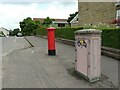
Street furniture
Pillar box (postbox number G13 766) and electricity distribution box beside Chamberlain Road.
Image: © Richard Sutcliffe
Taken: 12 Jul 2021
0.09 miles
2
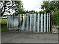
Electricity substation
Scottish Power's Chamberlain Road substation.
Image: © Richard Sutcliffe
Taken: 12 Jul 2021
0.11 miles
3
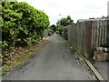
Munro Lane
Access road behind the houses on Munro Road.
Image: © Richard Sutcliffe
Taken: 12 Jul 2021
0.11 miles
4
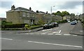
Munro Road
At its junction with Chamberlain Road.
Image: © Richard Sutcliffe
Taken: 12 Jul 2021
0.12 miles
5
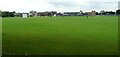
Playing fields, Old Anniesland
The High School of Glasgow have rugby pitches, hockey pitches (which convert into 12 tennis courts during the summer months), cricket pitches, athletics tracks and areas for field events on their ground at Old Anniesland.
Image: © Richard Sutcliffe
Taken: 12 Jul 2021
0.12 miles
6
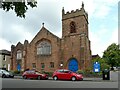
Jordanhill Parish Church
The church on Woodend Drive is Category B listed http://portal.historicenvironment.scot/designation/LB32347 and dates from 1904-5.
Image: © Richard Sutcliffe
Taken: 12 Jul 2021
0.12 miles
7
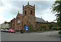
Jordanhill Parish Church
The church on Woodend Drive is Category B listed http://portal.historicenvironment.scot/designation/LB32347 and dates from 1904-5.
Image: © Richard Sutcliffe
Taken: 12 Jul 2021
0.13 miles
8
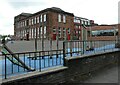
Jordanhill Training College Demonstration School
The Category B listed http://portal.historicenvironment.scot/designation/LB32303 Demonstration School was built in 1913. This view from Chamberlain Road shows the rear and side of the building. Image shows the front of the building.
Image: © Richard Sutcliffe
Taken: 12 Jul 2021
0.14 miles
9
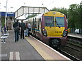
Anniesland railway station, looking SSW
Anniesland station, looking roughly SSW. 334 021 is at platform 1 with the 19:14 service to Larkhall.
Image: © Andrew Reid
Taken: 5 Aug 2011
0.14 miles