IMAGES TAKEN NEAR TO
Strathcona Drive, GLASGOW, G13 1JQ
Introduction
This page details the photographs taken nearby to Strathcona Drive, G13 1JQ by members of the Geograph project.
The Geograph project started in 2005 with the aim of publishing, organising and preserving representative images for every square kilometre of Great Britain, Ireland and the Isle of Man.

There are currently over 7.5m images from over14,400 individuals and you can help contribute to the project by visiting https://www.geograph.org.uk
Image Map
Images are licensed for reuse under creativecommons.org/licenses/by-sa/2.0
Notes
- Clicking on the map will re-center to the selected point.
- The higher the marker number, the further away the image location is from the centre of the postcode.
Image Listing (135 Images Found)
Images are licensed for reuse under creativecommons.org/licenses/by-sa/2.0
Image
Details
Distance
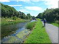
2
The Forth and Clyde Canal
Temple Road is invisible behind the trees on the left.
Image: © Jonathan Thacker
Taken: 21 Jul 2013
0.02 miles
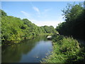
3
Forth and Clyde Canal, Temple
The scene here belies the fact that this is an urban area. Note the water lilies - a sure sign that boats are few and far between.
Image: © Stephen McKay
Taken: 25 Jun 2019
0.02 miles
4
![Forth and Clyde Canal [48]](https://s3.geograph.org.uk/geophotos/06/25/02/6250295_073ca038_120x120.jpg)
Forth and Clyde Canal [48]
A view from the towpath looking down onto the Maryhill Line as it passes underneath the canal and sweeps left to join the North Clyde Line.
The Forth and Clyde Canal was completed in 1790 and it provided a route for vessels between the Firth of Forth and the Firth of Clyde at the narrowest part (35 miles, 56km) of the Scottish Lowlands. Closed in 1963, the canal became semi-derelict. Millennium funds were used to regenerate the canal. The main line of the canal is a Scheduled Monument with details at: http://portal.historicenvironment.scot/designation/SM6774
Image: © Michael Dibb
Taken: 25 Jun 2019
0.02 miles
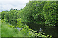
5
![Forth and Clyde Canal [49]](https://s1.geograph.org.uk/geophotos/06/25/03/6250301_6cb3b691_120x120.jpg)
Forth and Clyde Canal [49]
A small bird at the water's edge.
The Forth and Clyde Canal was completed in 1790 and it provided a route for vessels between the Firth of Forth and the Firth of Clyde at the narrowest part (35 miles, 56km) of the Scottish Lowlands. Closed in 1963, the canal became semi-derelict. Millennium funds were used to regenerate the canal. The main line of the canal is a Scheduled Monument with details at: http://portal.historicenvironment.scot/designation/SM6774
Image: © Michael Dibb
Taken: 25 Jun 2019
0.03 miles
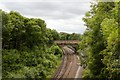
6
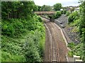
Railway line at Kelvindale
Railway line at Kelvindale viewed from the towpath of the Forth and Clyde Canal.
Image: © Philip Halling
Taken: 25 Jun 2019
0.03 miles
7
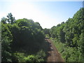
Railway to Anniesland
Originally opened by the North British Railway in 1874 to give access to Queens Dock. The line closed in 1980. After rebuilding the line re-opened in 2005 providing a link between Maryhill and Anniesland.
Image: © Jonathan Thacker
Taken: 21 Jul 2013
0.03 miles
8
![Glasgow buildings [14]](https://s2.geograph.org.uk/geophotos/06/25/02/6250298_599bcfb6_120x120.jpg)
Glasgow buildings [14]
Number 5 gasholder is one of the two remaining gasholders at Temple Gasholder Station, seen from the towpath of the Forth and Clyde Canal. Built in 1900 and capable of holding 141,584 cubic metres of gas, this holder and its companion number 4 are two of the last remaining examples of the 19th – early 20th century gas industry in Scotland and a reminder of the former industrial use of the site.
Recently listed, category B, there is a great deal of detail and history at: http://portal.historicenvironment.scot/designation/LB52443
Image: © Michael Dibb
Taken: 25 Jun 2019
0.03 miles
9
Railway between Kelvindale and Anniesland
Viewed from the Forth and Clyde Canal.
Image: © Mark Anderson
Taken: 25 Jun 2019
0.04 miles
10
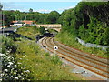
Railway line at Temple
This is part of the un-electrified Kelvindale line from Anniesland to Glasgow Queen Street.
Image: © Richard Sutcliffe
Taken: 12 Jul 2017
0.04 miles