IMAGES TAKEN NEAR TO
Anniesland Industrial Estate, GLASGOW, G13 1EU
Introduction
This page details the photographs taken nearby to Anniesland Industrial Estate, G13 1EU by members of the Geograph project.
The Geograph project started in 2005 with the aim of publishing, organising and preserving representative images for every square kilometre of Great Britain, Ireland and the Isle of Man.

There are currently over 7.5m images from over14,400 individuals and you can help contribute to the project by visiting https://www.geograph.org.uk
Image Map
Images are licensed for reuse under creativecommons.org/licenses/by-sa/2.0
Notes
- Clicking on the map will re-center to the selected point.
- The higher the marker number, the further away the image location is from the centre of the postcode.
Image Listing (28 Images Found)
Images are licensed for reuse under creativecommons.org/licenses/by-sa/2.0
Image
Details
Distance
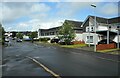
1
Anniesland Business Park
A wide variety of services are available in the business park.
Image: © Richard Sutcliffe
Taken: 9 Jun 2015
0.05 miles
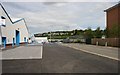
2
Forth and Clyde Canal
The canal at Netherton.
Image: © Richard Webb
Taken: 9 May 2012
0.15 miles
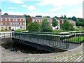
3
![Forth and Clyde Canal [54]](https://s1.geograph.org.uk/geophotos/06/25/03/6250309_9089dba4_120x120.jpg)
Forth and Clyde Canal [54]
The bridge at Old Farm Road is a swing bridge.
The Forth and Clyde Canal was completed in 1790 and it provided a route for vessels between the Firth of Forth and the Firth of Clyde at the narrowest part (35 miles, 56km) of the Scottish Lowlands. Closed in 1963, the canal became semi-derelict. Millennium funds were used to regenerate the canal. The main line of the canal is a Scheduled Monument with details at: http://portal.historicenvironment.scot/designation/SM6774
Image: © Michael Dibb
Taken: 25 Jun 2019
0.17 miles
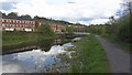
4
Footbridge over the Forth & Clyde Canal
At Netherton in north Glasgow.
Image: © Gordon Brown
Taken: 24 Jul 2017
0.17 miles
6
Tambowie Street
Street off Fulton Street.
Image: © Richard Sutcliffe
Taken: 26 May 2022
0.18 miles
7
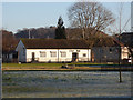
Temple recreation ground
The Hall within the park, which is on the site of Knightswood brickworks, which closed in the early 1930s https://www.scottishbrickhistory.co.uk/knightswood-brickworks-knightswood-glasgow/ .
Not to be confused with the adjacent The Hut Image
Image: © Thomas Nugent
Taken: 31 Dec 2019
0.18 miles
8
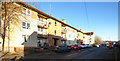
Wilverton Road
Wamba Avenue is just out of sight on the left.
Image: © Thomas Nugent
Taken: 31 Dec 2019
0.20 miles
9
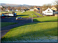
Temple recreation ground
The Hall and The Hut within the park, which is on the site of Knightswood brickworks, which closed in the early 1930s https://www.scottishbrickhistory.co.uk/knightswood-brickworks-knightswood-glasgow/ . The mineral line which served the works ran away from the camera and into the distance. Taken from the former railway bridge on Fulton Street.
Image: © Thomas Nugent
Taken: 31 Dec 2019
0.20 miles
10
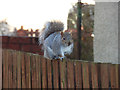
Squirrel on a fence
An urban grey squirrel, on a fence between houses on Avenel Road.
See also Image
Image: © Thomas Nugent
Taken: 31 Dec 2019
0.20 miles