IMAGES TAKEN NEAR TO
Caledon Street, GLASGOW, G12 9DY
Introduction
This page details the photographs taken nearby to Caledon Street, G12 9DY by members of the Geograph project.
The Geograph project started in 2005 with the aim of publishing, organising and preserving representative images for every square kilometre of Great Britain, Ireland and the Isle of Man.

There are currently over 7.5m images from over14,400 individuals and you can help contribute to the project by visiting https://www.geograph.org.uk
Image Map
Images are licensed for reuse under creativecommons.org/licenses/by-sa/2.0
Notes
- Clicking on the map will re-center to the selected point.
- The higher the marker number, the further away the image location is from the centre of the postcode.
Image Listing (329 Images Found)
Images are licensed for reuse under creativecommons.org/licenses/by-sa/2.0
Image
Details
Distance
1
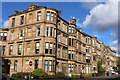
Corner of Caledon Street & Highburgh Road, Glasgow
Image: © Leslie Barrie
Taken: 23 Aug 2014
0.02 miles
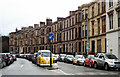
2
Highburgh Road
Viewed from Byres Road.
Image: © Thomas Nugent
Taken: 20 Oct 2007
0.06 miles
3
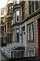
Highburgh Road
Ornate ironwork, including the drainpipes on this tenement at the corner of Byres Road.
Image: © Thomas Nugent
Taken: 21 Jan 2012
0.06 miles
4
Havelock Street
Tenements to the west of Byres Road. The church building has been converted to a restaurant.
Image: © Jim Smillie
Taken: 6 Mar 2010
0.06 miles
5
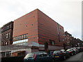
Extension to Dowanhill School
Dates from 2013. Architects: Hoskins Architects http://www.garethhoskinsarchitects.co.uk/projects/community-education/notre-dame-st-peters-primary-school-jru6 The school is now known as Notre Dame and St. Peter's Primary School.
Image: © Jonathan Thacker
Taken: 30 Mar 2016
0.07 miles
6
Dowanhill Primary School
Viewed from Dowanhill Street. See Image for more information.
Image: © Thomas Nugent
Taken: 20 Oct 2007
0.07 miles
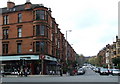
7
Junction of Byres Road and Highburgh Road
A major road junction near Glasgow University.
Image: © Stephen Craven
Taken: 26 Jun 2019
0.07 miles
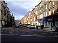
8
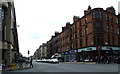
Byres Road
Looking down hill from the junction of Highburgh Road.
Image: © Thomas Nugent
Taken: 20 Oct 2007
0.08 miles
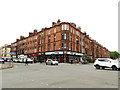
9
Dowanside Road
Category B Listed tenements http://data.historic-scotland.gov.uk/pls/htmldb/f?p=2200:15:0::::BUILDING:32501 on the north side of Dowanside Road at Byres Road.
Image: © Thomas Nugent
Taken: 8 Feb 2014
0.08 miles
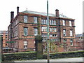
10
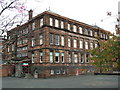
Dowanhill Primary School
A fine example of a red sandstone Victorian Glasgow public school, built in the 1890s. See also Image
Sadly threatened with closure and demolition.
Image: © Thomas Nugent
Taken: 20 Oct 2007
0.08 miles