IMAGES TAKEN NEAR TO
Grosvenor Crescent, GLASGOW, G12 9AF
Introduction
This page details the photographs taken nearby to Grosvenor Crescent, G12 9AF by members of the Geograph project.
The Geograph project started in 2005 with the aim of publishing, organising and preserving representative images for every square kilometre of Great Britain, Ireland and the Isle of Man.

There are currently over 7.5m images from over14,400 individuals and you can help contribute to the project by visiting https://www.geograph.org.uk
Image Map
Images are licensed for reuse under creativecommons.org/licenses/by-sa/2.0
Notes
- Clicking on the map will re-center to the selected point.
- The higher the marker number, the further away the image location is from the centre of the postcode.
Image Listing (409 Images Found)
Images are licensed for reuse under creativecommons.org/licenses/by-sa/2.0
Image
Details
Distance
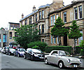
1
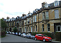
Grosvenor Crescent
Category B Listed buildings http://data.historic-scotland.gov.uk/pls/htmldb/f?p=2200:15:0::::BUILDING:32519 on the north side of the road. Viewed from Observatory Road.
Image: © Thomas Nugent
Taken: 27 Jul 2013
0.01 miles
2
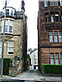
Observatory Lane
Off Observatory Road, near Byres Road.
Image: © Thomas Nugent
Taken: 27 Jul 2013
0.02 miles
3
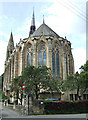
Belmont and Hillhead Parish Church
A Category A Listed building http://data.historic-scotland.gov.uk/pls/htmldb/f?p=2200:15:0::::BUILDING:32584 in French Gothic style, on Saultoun Street at Observatory Road.
Image: © Thomas Nugent
Taken: 27 Jul 2013
0.02 miles
4
Kelvinside Hillhead Parish Church, Glasgow
Image: © wfmillar
Taken: 15 Sep 2007
0.03 miles
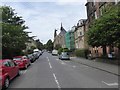
5
Observatory Road
Looking towards Byres Road.
Image: © Thomas Nugent
Taken: 27 Jul 2013
0.03 miles
6
Observatory Road
Looking up past residential terraces to Kelvinside Hillhead Parish Church Image
Image: © David Smith
Taken: 19 Jul 2017
0.03 miles
7
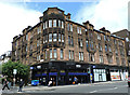
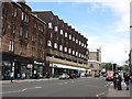
Byres Road
At Observatory Road, which is on the left.
Image: © Thomas Nugent
Taken: 1 Aug 2015
0.03 miles
8
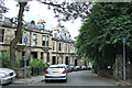
Grosvenor Crescent
Category B Listed buildings http://data.historic-scotland.gov.uk/pls/htmldb/f?p=2200:15:0::::BUILDING:32519 on the north side of the road. Viewed from Saltoun Street.
Image: © Thomas Nugent
Taken: 27 Jul 2013
0.03 miles
9
Byres Road
Northward view towards a residential block with a supermarket on the ground floor. This has changed brands many times and is currently a rare example of a Waitrose.
Image: © Richard Webb
Taken: 9 May 2012
0.04 miles
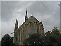
10

Belmont Hillhead Parish Church, east end
Dates from 1875. Architect: James Sellar http://www.britishlistedbuildings.co.uk/sc-32584-23-saltoun-street-belmont-and-hillhead-pa#.VwbO50fkoeU
Image: © Jonathan Thacker
Taken: 31 Mar 2016
0.04 miles