IMAGES TAKEN NEAR TO
Kersland Lane, GLASGOW, G12 8SA
Introduction
This page details the photographs taken nearby to Kersland Lane, G12 8SA by members of the Geograph project.
The Geograph project started in 2005 with the aim of publishing, organising and preserving representative images for every square kilometre of Great Britain, Ireland and the Isle of Man.

There are currently over 7.5m images from over14,400 individuals and you can help contribute to the project by visiting https://www.geograph.org.uk
Image Map
Images are licensed for reuse under creativecommons.org/licenses/by-sa/2.0
Notes
- Clicking on the map will re-center to the selected point.
- The higher the marker number, the further away the image location is from the centre of the postcode.
Image Listing (448 Images Found)
Images are licensed for reuse under creativecommons.org/licenses/by-sa/2.0
Image
Details
Distance
1
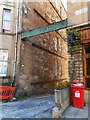
Sandringham Lane
The sign across the lane was for Caledonia Architectural Salvage Emporium [http://www.geograph.org.uk/photo/5824166].
Image: © Richard Sutcliffe
Taken: 28 Jun 2018
0.02 miles
2
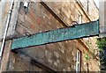
Sign for Caledonia Architectural Salvage Emporium
The sign above the entrance to Sandringham Lane has seen better days and should probably be up for Architectural Salvage itself. There used to be lights attached to the top of the sign to illuminate it at night (these were still there in 2014 on Streetview). The building which used to house the Emporium was demolished some time between 2014 and 2016.
Image: © Richard Sutcliffe
Taken: 28 Jun 2018
0.02 miles
3
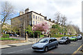
Buckingham Terrace
On the north side of Great Western Road at Buckingham Street. Category B Listed http://portal.historicenvironment.scot/designation/LB32850 .
Image: © Thomas Nugent
Taken: 15 Apr 2017
0.03 miles
4
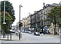
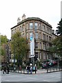
Great Western Road
Viewed from the junction with Queen Margaret Drive and Byres Road. Note the washed and unwashed sandstone tenements.
Image: © Thomas Nugent
Taken: 20 Oct 2007
0.03 miles
5
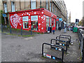
Shelter Scotland charity shop on Great Western Road
Celebrating 50 years of Shelter in Scotland http://scotland.shelter.org.uk/ , but the colour scheme and heart designs make it look more like a British Heart Foundation shop.
Image: © Thomas Nugent
Taken: 19 Nov 2020
0.03 miles
6
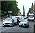
Great Western Road
Looking east from Byres Road.
Image: © Thomas Nugent
Taken: 4 Aug 2012
0.03 miles
7
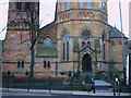
The Oran Mor
Formerly The Kelvinside Parish Church it was built in 1862. It opened its doors as the Oran Mor in 2004 after a major refurbishment.
Image: © Lynn M Reid
Taken: 26 Mar 2008
0.05 miles
8
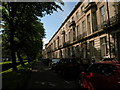
Buckingham Terrace
One of several terraces screened by trees from the main Great Western Road. J. T. Rochead, 1858.
Image: © Keith Edkins
Taken: 10 Jun 2011
0.05 miles
9
Great Western Road
Great Western Road is to the right, Queen Margaret Drive to the left and the cars are parked on Buckingham Terrace.
Image: © Thomas Nugent
Taken: 20 Oct 2007
0.05 miles
