IMAGES TAKEN NEAR TO
Bank Street, GLASGOW, G12 8NF
Introduction
This page details the photographs taken nearby to Bank Street, G12 8NF by members of the Geograph project.
The Geograph project started in 2005 with the aim of publishing, organising and preserving representative images for every square kilometre of Great Britain, Ireland and the Isle of Man.

There are currently over 7.5m images from over14,400 individuals and you can help contribute to the project by visiting https://www.geograph.org.uk
Image Map
Images are licensed for reuse under creativecommons.org/licenses/by-sa/2.0
Notes
- Clicking on the map will re-center to the selected point.
- The higher the marker number, the further away the image location is from the centre of the postcode.
Image Listing (403 Images Found)
Images are licensed for reuse under creativecommons.org/licenses/by-sa/2.0
Image
Details
Distance
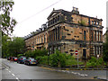
1
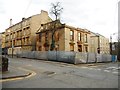
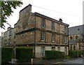
Building at the junction of Bath Street and Great George Street
This Category B listed building [http://portal.historicenvironment.scot/designation/LB32196] appears to be under refurbishment. There is evidence of replacement stonework at the top left.
Image: © Richard Sutcliffe
Taken: 14 Mar 2018
0.01 miles
2
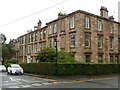
65 Bank Street, Hillhead
3 storey tenement block of c.1852, Listed Category B http://portal.historicenvironment.scot/designation/LB32178 .
The adjacent buildings to its left on Great George Street are similarly listed, http://portal.historicenvironment.scot/designation/LB32195
Image: © Alan Murray-Rust
Taken: 24 Jun 2019
0.03 miles
3
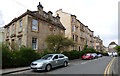
Otago Street at Great George Street
The building on the left fronts onto Great George Street and is Category B Listed http://portal.historicenvironment.scot/designation/LB32196 .
Image: © Thomas Nugent
Taken: 15 Apr 2017
0.04 miles
4
Otago Street
Otago Street is to the right, Great George Street to the left.
Image: © Thomas Nugent
Taken: 20 Nov 2010
0.04 miles
5

Sign on Otago Street
The business is located in Otago Lane.
Image: © Thomas Nugent
Taken: 20 Nov 2010
0.05 miles
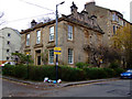
6
69 Bank Street, Hillhead
One of a pair of 3 storey tenement blocks, on the corner of Bank Street and Gibson Street, built c.1852, Listed Category B http://portal.historicenvironment.scot/designation/LB32178 .
Image: © Alan Murray-Rust
Taken: 24 Jun 2019
0.06 miles
7
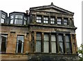
Tenement row, Oakfield Avenue ? 3
The south end pavilion of the row https://www.geograph.org.uk/photo/6193306 , built 1865 by Alexander 'Greek' Thomson, showing his use of classical Greek detailing. Listed Category A http://portal.historicenvironment.scot/designation/LB32235 .
Image: © Alan Murray-Rust
Taken: 24 Jun 2019
0.06 miles
8
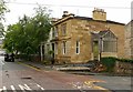
27 Bank Street, Hillhead
Recently refurbished after years of neglect.
End house of a terrace (formerly Bothwell Terrace) of 12 houses of c.1863, Listed Category B http://portal.historicenvironment.scot/designation/LB32177 . The porch is a later (but not recent) replacement for the original stepped entrance on Bank Street.
Image: © Alan Murray-Rust
Taken: 24 Jun 2019
0.06 miles
9
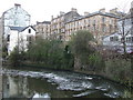
Otago Street
Viewed from the west bank of the River Kelvin at Kelvinbridge.
Image: © Thomas Nugent
Taken: 16 Apr 2008
0.06 miles
10
Tenement row, Oakfield Avenue - 1
Built 1865 by Alexander 'Greek' Thompson, displaying his distinctive Greek detailing. Listed Category A, although the end block looks somewhat run down.
Image: © Alan Murray-Rust
Taken: 24 Jun 2019
0.06 miles