IMAGES TAKEN NEAR TO
Kirklee Road, GLASGOW, G12 0SS
Introduction
This page details the photographs taken nearby to Kirklee Road, G12 0SS by members of the Geograph project.
The Geograph project started in 2005 with the aim of publishing, organising and preserving representative images for every square kilometre of Great Britain, Ireland and the Isle of Man.

There are currently over 7.5m images from over14,400 individuals and you can help contribute to the project by visiting https://www.geograph.org.uk
Image Map
Images are licensed for reuse under creativecommons.org/licenses/by-sa/2.0
Notes
- Clicking on the map will re-center to the selected point.
- The higher the marker number, the further away the image location is from the centre of the postcode.
Image Listing (87 Images Found)
Images are licensed for reuse under creativecommons.org/licenses/by-sa/2.0
Image
Details
Distance
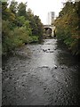
1
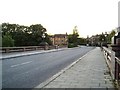
Bridge over River Kelvin at Kirklee Road
Looking northwest.
Image: © Stephen Sweeney
Taken: 3 Sep 2007
0.05 miles
2

Kirklee Road bridge
A rather grand bridge carrying Kirklee Road over the River Kelvin in the west end of the city. Category B Listed http://portal.historic-scotland.gov.uk/designation/LB32549 .
Image: © Thomas Nugent
Taken: 19 Mar 2016
0.05 miles
3

Kirklee Road bridge
A rather grand bridge carrying Kirklee Road over the River Kelvin in the west end of the city. Category B Listed http://portal.historic-scotland.gov.uk/designation/LB32549 .
Image: © Thomas Nugent
Taken: 19 Mar 2016
0.05 miles
4
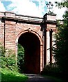
Kirklee Road Bridge
Looking upstream at one of the footpath portals. The bridge is faced with red sandstone and the two columns are of red granite. The main span of the bridge (behind the trees) carries the coat of arms of the City of Glasgow.
Image: © Patrick Mackie
Taken: 17 Aug 2008
0.06 miles
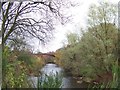
5
River Kelvin at Garioch Bridge
After Image further comment would be superfluous
Image: © Keith Edkins
Taken: 5 Jun 2011
0.06 miles
6
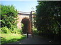
Kirklee Bridge
One of Glasgow's finest bridges. This shows just the western end and the pedestrian way which passes beneath. Built 1899-1901 and designed by Charles Formans.
Image: © Jonathan Thacker
Taken: 21 Jul 2013
0.07 miles
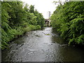
7
River Kelvin
View upstream towards the viaducts that carried the now closed Lanarkshire and Dunbartonshire Railway - later Caledonian railway over the river to Maryhill. Taken from a footbridge leading to the Botanic Gardens Arboretum.
Image: © Richard Webb
Taken: 26 Sep 2009
0.07 miles

9
Kirklee Road bridge crossing the river Kelvin
Image: © Elliott Simpson
Taken: 10 Nov 2007
0.08 miles
10

Kirklee Road bridge
A rather grand bridge carrying Kirklee Road over the River Kelvin in the west end of the city. Category B Listed http://portal.historic-scotland.gov.uk/designation/LB32549 .
Image: © Thomas Nugent
Taken: 19 Mar 2016
0.08 miles