IMAGES TAKEN NEAR TO
Kelvindale Court, GLASGOW, G12 0HA
Introduction
This page details the photographs taken nearby to Kelvindale Court, G12 0HA by members of the Geograph project.
The Geograph project started in 2005 with the aim of publishing, organising and preserving representative images for every square kilometre of Great Britain, Ireland and the Isle of Man.

There are currently over 7.5m images from over14,400 individuals and you can help contribute to the project by visiting https://www.geograph.org.uk
Image Map
Images are licensed for reuse under creativecommons.org/licenses/by-sa/2.0
Notes
- Clicking on the map will re-center to the selected point.
- The higher the marker number, the further away the image location is from the centre of the postcode.
Image Listing (146 Images Found)
Images are licensed for reuse under creativecommons.org/licenses/by-sa/2.0
Image
Details
Distance
1
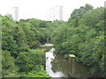
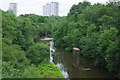
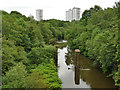
The River Kelvin
Looking downstream from the Kelvin Aqueduct on the Forth & Clyde Canal.
Image: © M J Richardson
Taken: 25 Jun 2019
0.04 miles
2
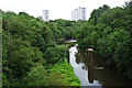
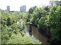
River Kelvin
Looking downstream from the Kelvin Aqueduct. The pillars look like the supports of a railway bridge, but none of the historic Ordnance Survey maps shows a bridge there.
Image: © Anne Burgess
Taken: 25 Jun 2019
0.04 miles
3
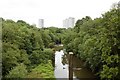
River Kelvin
Viewed from the Forth and Clyde Canal viaduct. The bridge supports in the foreground were for a railway line.
Image: © Mark Anderson
Taken: 25 Jun 2019
0.04 miles
4
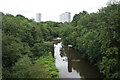
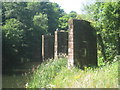
Glimpses of an industrial past
Looking from the Kelvin Aqueduct (Forth and Clyde Canal) over the River Kelvin it is hard to believe this tranquil scene was once a hive of industry. To the left there used to be several railway lines and for a short time, Dawsholm station. This opened in 1896, but closed to passengers in 1908. The masonry pillars once carried a single railway track across the river to reach the Temple Gasworks three quarters of a mile to the west. The railway closed in 1966.
Beyond is a weir, which held back water to supply Kelvindale Paper Mills.
Image: © Richard Sutcliffe
Taken: 25 Jun 2019
0.04 miles
5
Piers with herons
The piers mark the site of a bridge on a branch over the River Kelvin of the Lanarkshire and Dumbartonshire Railway which served Temple Gasworks.
Image: © Jonathan Thacker
Taken: 21 Jul 2013
0.05 miles
6
River Kelvin, Maryhill
Looking down from the aqueduct on the Forth and Clyde Canal. The piers in the river carried a branch line that served the nearby Temple Gas Works. There were other connections to the works and this route closed as long ago as 1920.
Image: © Stephen McKay
Taken: 25 Jun 2019
0.05 miles
7
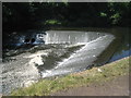
Weir on the River Kelvin
Near Wyndford.
Image: © Jonathan Thacker
Taken: 21 Jul 2013
0.05 miles
8
Weir on the River Kelvin near Queen Margaret Bridge
Just downstream from the canal aqueduct.
Image: © Gordon Brown
Taken: 9 Jun 2019
0.05 miles
9
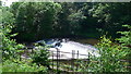
River Kelvin from the aqueduct
Looking down towards a weir; in between are the two piers of a former railway viaduct that crossed river on a skew angle.
Image: © Stephen Craven
Taken: 25 Jun 2019
0.05 miles
10
River Kelvin
Picture taken from Forth & Clyde canal.
Image: © william craig
Taken: 5 Jun 2005
0.05 miles