IMAGES TAKEN NEAR TO
Eider, GLASGOW, G12 0FD
Introduction
This page details the photographs taken nearby to Eider, G12 0FD by members of the Geograph project.
The Geograph project started in 2005 with the aim of publishing, organising and preserving representative images for every square kilometre of Great Britain, Ireland and the Isle of Man.

There are currently over 7.5m images from over14,400 individuals and you can help contribute to the project by visiting https://www.geograph.org.uk
Image Map
Images are licensed for reuse under creativecommons.org/licenses/by-sa/2.0
Notes
- Clicking on the map will re-center to the selected point.
- The higher the marker number, the further away the image location is from the centre of the postcode.
Image Listing (172 Images Found)
Images are licensed for reuse under creativecommons.org/licenses/by-sa/2.0
Image
Details
Distance
1
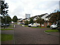
Eider, Anniesland (2)
Looking towards its junction with Murchison.
Image: © Richard Vince
Taken: 12 Sep 2022
0.01 miles
2
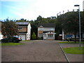
Eider, Anniesland (1)
The end of a cul de sac off Murchison.
Image: © Richard Vince
Taken: 12 Sep 2022
0.01 miles
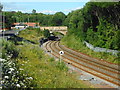
4
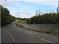
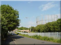
Bridge over the railway, Strathcona Drive
The bridge carries Strathcona Drive over the railway line between Anniesland and Westerton. The barriers restrict the bridge to single-file traffic, and traffic coming from the far side has priority.
Behind the bridge is a gantry marking the end of a short electrified section of the Kelvindale line from Anniesland to Glasgow Queen Street, just at the Knightswood South Junction, where it meets the Anniesland to Westerton line [http://www.geograph.org.uk/photo/5460089].
Behind this are the two gasholders of the Temple Gas Works, which are Category B listed http://portal.historicenvironment.scot/designation/LB52443.
Image: © Richard Sutcliffe
Taken: 12 Jul 2017
0.05 miles
5
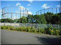
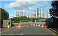
Gasholders, Temple Gasworks
Seen from Strathcona Drive. The gasholders are both Category B listed http://portal.historicenvironment.scot/designation/LB52443.
Image: © Richard Sutcliffe
Taken: 12 Jul 2017
0.06 miles
6
Gasholder, Temple Gasworks
Seen from Strathcona Drive. The gasholder is one of two which are Category B listed http://portal.historicenvironment.scot/designation/LB52443.
Image: © Richard Sutcliffe
Taken: 12 Jul 2017
0.06 miles
9
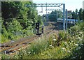
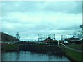
Knightswood South Junction, Temple
Here the un-electrified Kelvindale line from Glasgow Queen Street to Anniesland joins the electrified line between Anniesland and Westerton. A train from Westerton is just crossing the junction.
Image: © Richard Sutcliffe
Taken: 12 Jul 2017
0.07 miles
10
Railway line at Temple
This is part of the un-electrified Kelvindale line from Anniesland to Glasgow Queen Street.
Image: © Richard Sutcliffe
Taken: 12 Jul 2017
0.08 miles