IMAGES TAKEN NEAR TO
Westerlands, GLASGOW, G12 0FB
Introduction
This page details the photographs taken nearby to Westerlands, G12 0FB by members of the Geograph project.
The Geograph project started in 2005 with the aim of publishing, organising and preserving representative images for every square kilometre of Great Britain, Ireland and the Isle of Man.

There are currently over 7.5m images from over14,400 individuals and you can help contribute to the project by visiting https://www.geograph.org.uk
Image Map
Images are licensed for reuse under creativecommons.org/licenses/by-sa/2.0
Notes
- Clicking on the map will re-center to the selected point.
- The higher the marker number, the further away the image location is from the centre of the postcode.
Image Listing (148 Images Found)
Images are licensed for reuse under creativecommons.org/licenses/by-sa/2.0
Image
Details
Distance
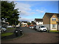
1
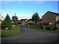
Westerlands, Anniesland
Off Ascot Avenue.
Image: © Richard Vince
Taken: 12 Sep 2022
0.04 miles
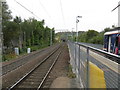
2
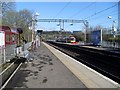
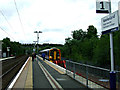
Anniesland Railway Station
From the westbound platform for the Clydebank-bound service.
Image: © Stephen Sweeney
Taken: 25 Mar 2009
0.05 miles
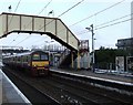
3
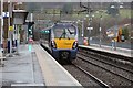
A Class 334 electric train departs Anniesland Train Station
A Class 334, (334028), departing from Anniesland train station on a Helensburgh Central service. Anniesland station has 3 platforms, two of which are on the Argyle line. Platform 3 is a non electric line that leads to Glasgow Queen Street upper level through the North of Glasgow.
Image: © Garry Cornes
Taken: 31 Jan 2016
0.05 miles
4
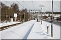
Snow covered platforms at Anniesland railway station
As a result of a snow front over Central Scotland train services are all cancelled.
The snow fall nicknamed The Beast From The East hit Glasgow on 1st March 2018.
The train tracks are not visible due to the depth of the snow.
This shot was taken from platform 2 looking North with the next stations down the 2 outgoing lines being Kelvindale and Westerton.
Image: © Garry Cornes
Taken: 1 Mar 2018
0.05 miles
5

Ascot Avenue, Anniesland
Approaching the junction with Hutton.
Image: © Richard Vince
Taken: 12 Sep 2022
0.05 miles
6
Murchison, Anniesland
Off Ascot Avenue.
Image: © Richard Vince
Taken: 12 Sep 2022
0.05 miles
7
View north from Anniesland station
A view taken from one of the original two platforms showing the extra platform shoehorned in for the Glasgow-Maryhill-Anniesland diesel shuttle. At one time, the line from Maryhill joined north of Anniesland in a simple junction, but there is no longer any physical connection.
Image: © Peter Whatley
Taken: 14 Sep 2014
0.06 miles
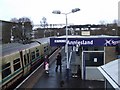
8
Anniesland railway station
In the west end of Glasgow on the Milngavie Line,
Image: © Thomas Nugent
Taken: 30 Dec 2009
0.06 miles
9
Anniesland railway station
The view of the south bound platform from the footbridge.
Image: © Thomas Nugent
Taken: 30 Dec 2009
0.06 miles
10
Anniesland railway station
The line on the right runs to Queen Street high level station. The lines on the left run to Glasgow Central low level, Queen Street low level, Milngavie and Dalmuir.
Image: © Thomas Nugent
Taken: 10 Aug 2013
0.06 miles