IMAGES TAKEN NEAR TO
Fifth Avenue, GLASGOW, G12 0AT
Introduction
This page details the photographs taken nearby to Fifth Avenue, G12 0AT by members of the Geograph project.
The Geograph project started in 2005 with the aim of publishing, organising and preserving representative images for every square kilometre of Great Britain, Ireland and the Isle of Man.

There are currently over 7.5m images from over14,400 individuals and you can help contribute to the project by visiting https://www.geograph.org.uk
Image Map
Images are licensed for reuse under creativecommons.org/licenses/by-sa/2.0
Notes
- Clicking on the map will re-center to the selected point.
- The higher the marker number, the further away the image location is from the centre of the postcode.
Image Listing (126 Images Found)
Images are licensed for reuse under creativecommons.org/licenses/by-sa/2.0
Image
Details
Distance
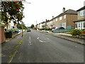

5
Whittingehame Drive
Looking up the hill.
Image: © Richard Sutcliffe
Taken: 30 Oct 2016
0.10 miles
6
Whitingehame Drive
Through motorised traffic has been blocked off.
Image: © Richard Webb
Taken: 19 Jan 2014
0.10 miles
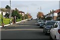
7

Hatfield Drive, Anniesland
From Fifth Avenue, looking to the new building on the Anniesland College campus.
Image: © Stephen Sweeney
Taken: 10 Jun 2008
0.10 miles
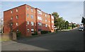
9
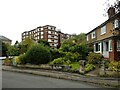
Kelvin Court
The western end of Kelvin Court, seen from Fifth Avenue. This is one of the two H-plan apartment blocks by J N Fatkin, dating from 1938, which face onto Great Western Road. It is Category B listed https://portal.historicenvironment.scot/designation/LB32321
Image: © Richard Sutcliffe
Taken: 2 Aug 2023
0.11 miles
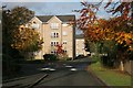
10
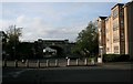
Railway bridge, Whittingehame Drive
Whittingehame Drive was formally a through route from Crow Road (beyond the bridge) to Great Western Road, and much used as a shortcut. There are now bollards which prevent traffic using the complete road. The short section of Whittingehame Drive which passes under the railway now only leads into Shelly Road (to the left of the photograph).
Image: © Richard Sutcliffe
Taken: 30 Oct 2016
0.11 miles