IMAGES TAKEN NEAR TO
Blackfriars Road, GLASGOW, G1 1QG
Introduction
This page details the photographs taken nearby to Blackfriars Road, G1 1QG by members of the Geograph project.
The Geograph project started in 2005 with the aim of publishing, organising and preserving representative images for every square kilometre of Great Britain, Ireland and the Isle of Man.

There are currently over 7.5m images from over14,400 individuals and you can help contribute to the project by visiting https://www.geograph.org.uk
Image Map
Images are licensed for reuse under creativecommons.org/licenses/by-sa/2.0
Notes
- Clicking on the map will re-center to the selected point.
- The higher the marker number, the further away the image location is from the centre of the postcode.
Image Listing (934 Images Found)
Images are licensed for reuse under creativecommons.org/licenses/by-sa/2.0
Image
Details
Distance
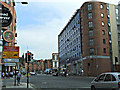
1
Looking south on High Street
Past the train station on the left, down to the Tolbooth Steeple at Glasgow Cross.
Image: © Stephen Sweeney
Taken: 19 Jan 2008
0.01 miles
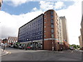
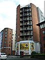
2
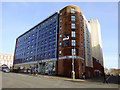
High Street
New flats at the corner of Blackfriars Road.
Image: © Thomas Nugent
Taken: 28 Feb 2016
0.02 miles
3
Aldi in the High Street
It astonishes me that the old University of Glasgow was flattened in the 1870s to make way for a railway goods yard. Now shops and flats occupy part of the site. I suppose the College's one-time Professor of Moral Philosophy, Adam Smith, would just put it down to market forces.
"On the left-hand of the same street is the university, the building is the best of any in Scotland of the kind; it was founded by Bishop Turnbull, Ann. 1454, but has been much enlarged since, and the fabric almost all new built. It is a very spacious building, contains two large squares, or courts, and the lodgings for the scholars, and for the professors, are very handsome; the whole building is of freestone, very high and very august."
-- Daniel Defoe, A Tour Thro' The Whole Island of Great Britain, 1724-6
Image: © kim traynor
Taken: 26 Mar 2012
0.02 miles
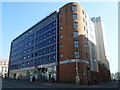
4
Retail and housing development
A Aldi supermarket and pharmacy in a new building with housing above.
Image: © Mat Tuck
Taken: 19 Aug 2013
0.02 miles
5
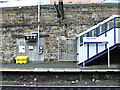
High Street railway station
Traces of an old door on the west bound platform which possibly led to the former goods station.
Image: © Thomas Nugent
Taken: 12 Jul 2014
0.03 miles
6
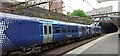
Scotrail train at High Street Station
West bound at Platform 1.
Image: © Thomas Nugent
Taken: 15 Jun 2024
0.03 miles
7
High Street
The A8 road at Ingram Street.
Image: © Thomas Nugent
Taken: 26 Aug 2013
0.03 miles
8
High Street
Looking towards Blackfriars Road, which is between the two buildings.
Image: © Thomas Nugent
Taken: 26 Aug 2013
0.03 miles
9

High Street
View downhill past the entrance to High Street Station.
Image: © Richard Webb
Taken: 25 Jul 2008
0.03 miles
10

High Street railway station
Scotrail Class 334 train number 334036 on a "fast" service to Edinburgh Waverley. The stopping service followed a few minutes later Image
Image: © Thomas Nugent
Taken: 12 Jul 2014
0.03 miles