IMAGES TAKEN NEAR TO
John Street, GLASGOW, G1 1JH
Introduction
This page details the photographs taken nearby to John Street, G1 1JH by members of the Geograph project.
The Geograph project started in 2005 with the aim of publishing, organising and preserving representative images for every square kilometre of Great Britain, Ireland and the Isle of Man.

There are currently over 7.5m images from over14,400 individuals and you can help contribute to the project by visiting https://www.geograph.org.uk
Image Map (Loading...)


Getting Data...Please wait
Leaflet Map data © OpenStreetMap
Images are licensed for reuse under creativecommons.org/licenses/by-sa/2.0
Notes
- Clicking on the map will re-center to the selected point.
- The higher the marker number, the further away the image location is from the centre of the postcode.
Image Listing (1775 Images Found)
Images are licensed for reuse under creativecommons.org/licenses/by-sa/2.0
Image
Details
Distance
1
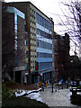
John Street
With Strathclyde University Students Union to the left.
See the same scene in 1966 here Image
Image: © Thomas Nugent
Taken: 9 Jan 2011
0.01 miles
3

George Square, Glasgow. Christmas lights 2005
Image: © Johnny Durnan
Taken: 16 Dec 2005
0.01 miles
4
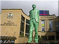
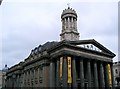
Glasgow Royal Concert Hall and Donald Dewar Statue
Image: © Richard Slessor
Taken: 1 Apr 2006
0.01 miles
5
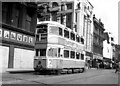
'Coronation' on Argyle Street
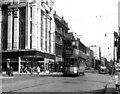
Argyle Street in the city centre was the best place to see tramway operation in Glasgow. Here we see Coronation car No 1174 on route 10.
Image: © Dr Neil Clifton
Taken: 10 Apr 1960
0.01 miles
6
A real Glasgow 'caur' on Argyle Street
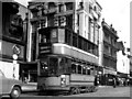
This is No 298, a Standard Glasgow car. Some of these cars were progressive rebuilds of cars that were originally built over 50 years previously. They had run well over a million miles in service. Route 10 ran from Botanic Gardens to the unpronounceable Auchenshuggle. We will not see their like again.
Image: © Dr Neil Clifton
Taken: 10 Apr 1960
0.01 miles
7
A 'hex-dash' Standard on Argyle Street
Most Glasgow standards had round front ends, but some like No 96 seen above, had a more angular appearance, and were known as 'hex-dash' cars. Route 15 ran from Baillieston to Anderston Cross.
Image: © Dr Neil Clifton
Taken: 10 Apr 1960
0.01 miles
8
Buchanan Street Subway station
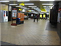
Buchanan Street Subway station concourse.
Image: © Andrew Reid
Taken: 2 Sep 2011
0.01 miles
9
Argyle Street
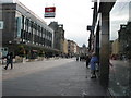
Looking roughly ESE along Argyle Street.
Image: © Andrew Reid
Taken: 24 Aug 2011
0.01 miles
10
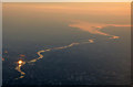
Glasgow and the Clyde at dusk from the air
The reflection is on the Science Centre building Image at Pacific Quay.
The entire length of the navigable Clyde from Glasgow Green (lower left corner) to the open firth at Port Glasgow can be seen here. Navigation is possible above Glasgow Green, but is blocked by the Tidal Weir Image
The river is not naturally navigable, having been much altered since the late 18th Century, until which time the 19 miles distant Port Glasgow was the site of the city's docks and harbours. Further reading is available in this geograph article http://www.geograph.org.uk/article/A-History-of-Port-Glasgow .
Image: © Thomas Nugent
Taken: 26 May 2017
0.01 miles