IMAGES TAKEN NEAR TO
Kirkmichael Gardens, GLASGOW, G11 7QP
Introduction
This page details the photographs taken nearby to Kirkmichael Gardens, G11 7QP by members of the Geograph project.
The Geograph project started in 2005 with the aim of publishing, organising and preserving representative images for every square kilometre of Great Britain, Ireland and the Isle of Man.

There are currently over 7.5m images from over14,400 individuals and you can help contribute to the project by visiting https://www.geograph.org.uk
Image Map (Loading...)


Getting Data...Please wait
Leaflet Map data © OpenStreetMap
Images are licensed for reuse under creativecommons.org/licenses/by-sa/2.0
Notes
- Clicking on the map will re-center to the selected point.
- The higher the marker number, the further away the image location is from the centre of the postcode.
Image Listing (97 Images Found)
Images are licensed for reuse under creativecommons.org/licenses/by-sa/2.0
Image
Details
Distance
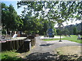
1
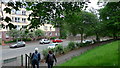
Leaving Cross Park for Crow Road, Glasgow
Different measuring methods yield different results, but all surveys seem to agree that Glasgow is one of the UK cities with the most green space. Cross Park is just one of the many large and small parks dotted around this historically industrial city.
Image: © Gordon Brown
Taken: 9 Jun 2019
0.08 miles
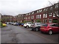
2
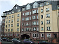
Flats on Crow Road
Modern flats overlooking Cross Park.
Image: © Thomas Nugent
Taken: 13 Apr 2013
0.08 miles
3
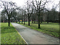
Cross Park
Looking up the hill towards Laurel Place.
Image: © Thomas Nugent
Taken: 13 Apr 2013
0.08 miles
4
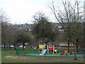
Cross Park
Looking down the hill towards Crow Road.
Image: © Thomas Nugent
Taken: 13 Apr 2013
0.09 miles
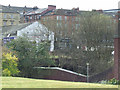
6
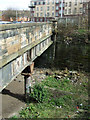
Former Crow Road railway station
The station opened in 1896 and closed on 6 November 1960. It was on the Lanarkshire and Dunbartonshire Railway link line between Partick West and Kelvinside stations. The single island platform still exists, but the buildings were removed in 1970. The bridge carries Clarence Drive.
Image: © Thomas Nugent
Taken: 13 Apr 2013
0.11 miles
7
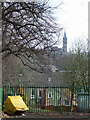
Laurel Place
With Glasgow University tower in the distance.
Image: © Thomas Nugent
Taken: 13 Apr 2013
0.11 miles
8
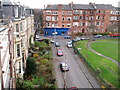
Hayburn Crescent Glasgow
Taken from a scaffold at 23 Hayburn Crescent, Turnberry Crescent crosses at the road junction.
Image: © Gordon Dowie
Taken: 22 Nov 2010
0.11 miles
9
Former Crow Road railway station
The station (which was located amongst the trees) opened in 1896 and closed on 6 November 1960. It was on the Lanarkshire and Dunbartonshire Railway link line between Partick West and Kelvinside stations. The single island platform still exists, but the buildings were removed in 1970. The bridge carries Clarence Drive.
Image: © Thomas Nugent
Taken: 13 Apr 2013
0.12 miles
10
Crow Road railway station (site), Glasgow
Opened in 1896 by the Lanarkshire and Dumbartonshire Railway, part of the Caledonian Railway, on the line from Possil to Dumbarton via Whiteinch, this station closed in 1960.
View south towards Whiteinch and Dumbarton. The housing occupies the site and alignment of the platform. At the far end, the remains of the entrance building on a raft over the railway lines, as well as a short length of platform underneath, was still extant when this image was taken.
Image: © Nigel Thompson
Taken: 21 Feb 2019
0.12 miles