IMAGES TAKEN NEAR TO
Broomhill Drive, GLASGOW, G11 7QA
Introduction
This page details the photographs taken nearby to Broomhill Drive, G11 7QA by members of the Geograph project.
The Geograph project started in 2005 with the aim of publishing, organising and preserving representative images for every square kilometre of Great Britain, Ireland and the Isle of Man.

There are currently over 7.5m images from over14,400 individuals and you can help contribute to the project by visiting https://www.geograph.org.uk
Image Map
Images are licensed for reuse under creativecommons.org/licenses/by-sa/2.0
Notes
- Clicking on the map will re-center to the selected point.
- The higher the marker number, the further away the image location is from the centre of the postcode.
Image Listing (98 Images Found)
Images are licensed for reuse under creativecommons.org/licenses/by-sa/2.0
Image
Details
Distance
1
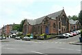
Balshagray Victoria Park Church of Scotland
Category B listed church http://portal.historicenvironment.scot/designation/LB33973, designed by Stewart and Paterson, 1907-12.
Image: © Richard Sutcliffe
Taken: 12 Jul 2021
0.00 miles
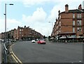
2
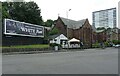
Pavilion cafe bistro and church
The Pavilion cafe bistro and Balshagray Victoria Park Church of Scotland sit beside the junction of Crow Road, Broomhill Drive and Clarence Drive. The church is Category B listed http://portal.historicenvironment.scot/designation/LB33973.
Image: © Richard Sutcliffe
Taken: 12 Jul 2021
0.01 miles
3
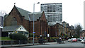
Crow Road at Broomhill Drive
Crow Road is in the foreground, Balshagray Victoria Park Parish Church is on the left.
Image: © Thomas Nugent
Taken: 13 Apr 2013
0.01 miles
5
Crow Road
At the junction with Broomhill Drive and Clarence Drive. Wee Paree on the right is a restaurant 'where Paris meets the west-end of Glasgow'.
Image: © Richard Sutcliffe
Taken: 12 Jul 2021
0.02 miles
6
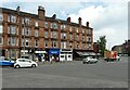
Shops and restaurant, Crow Road
A variety of shops including a newsagent, Chinese take-away, hairdressers and Wee Paree - a restaurant 'where Paris meets the west-end of Glasgow', with flats above.
Image: © Richard Sutcliffe
Taken: 12 Jul 2021
0.03 miles
7
Broomhill Drive
Viewed across Crow Road from Clarence Drive.
Image: © Thomas Nugent
Taken: 13 Apr 2013
0.03 miles
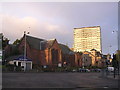
8
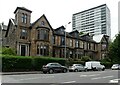
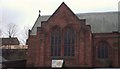
Terrace on Broomhill Drive
Category B listed http://portal.historicenvironment.scot/designation/LB32291 terrace, dating from 1891-2, contrasting with the modern tower block behind.
Image: © Richard Sutcliffe
Taken: 12 Jul 2021
0.03 miles
9
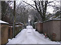
Back Lane
The view of the back lane between houses on Crow Road (on the left) and Randolph Road (on the right).
Image: © Sandy Gemmill
Taken: 25 Dec 2009
0.04 miles
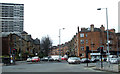
10
Broomhill Cross
The intersection of Crow Road, Clarence Drive and Broomhill Drive. Taken whilst waiting at the traffic lights, on my way to work. The church in the middle is Balshagray Victoria Park.The church was dedicated on 11th September 1909. Halls were added in 1911. Up until the early 1990s the church was simply called Balshagray, but "Victoria Park" was added to the name when the congregations of Balshagray and Victoria Park were united.
Image: © Chris Upson
Taken: 29 Sep 2005
0.04 miles