IMAGES TAKEN NEAR TO
Churchill Drive, GLASGOW, G11 7LQ
Introduction
This page details the photographs taken nearby to Churchill Drive, G11 7LQ by members of the Geograph project.
The Geograph project started in 2005 with the aim of publishing, organising and preserving representative images for every square kilometre of Great Britain, Ireland and the Isle of Man.

There are currently over 7.5m images from over14,400 individuals and you can help contribute to the project by visiting https://www.geograph.org.uk
Image Map
Images are licensed for reuse under creativecommons.org/licenses/by-sa/2.0
Notes
- Clicking on the map will re-center to the selected point.
- The higher the marker number, the further away the image location is from the centre of the postcode.
Image Listing (149 Images Found)
Images are licensed for reuse under creativecommons.org/licenses/by-sa/2.0
Image
Details
Distance
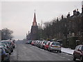
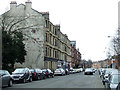
1
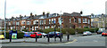
Randolph Road
Viewed across Clarence Drive. Churchill Drive is on the right.
Image: © Thomas Nugent
Taken: 13 Apr 2013
0.01 miles
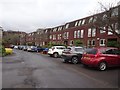
2
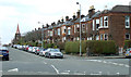
Randolph Road
Churchill Drive is to the right.
Image: © Thomas Nugent
Taken: 13 Apr 2013
0.02 miles
3
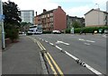
Cycle lane, Clarence Drive
Raised blocks help deter motorists from cutting into the cycle lane.
Image: © Richard Sutcliffe
Taken: 12 Jul 2021
0.04 miles
4
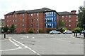
Clarence Court Care Home
The care home sited between Crow Road and Clarence Drive, has 40 bedrooms and provides nursing, palliative and respite care.
Image: © Richard Sutcliffe
Taken: 12 Jul 2021
0.04 miles
5
Randolph Road
The view of Randolph Road, looking towards Broomhill Parish Church
Image: © Sandy Gemmill
Taken: 25 Dec 2009
0.04 miles
6
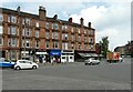
Shops and restaurant, Crow Road
A variety of shops including a newsagent, Chinese take-away, hairdressers and Wee Paree - a restaurant 'where Paris meets the west-end of Glasgow', with flats above.
Image: © Richard Sutcliffe
Taken: 12 Jul 2021
0.06 miles
7
Clarence Drive
The road crosses the former Crow Road railway station Image at this point.
Image: © Thomas Nugent
Taken: 13 Apr 2013
0.06 miles
8
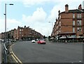
Crow Road
At the junction with Broomhill Drive and Clarence Drive. Wee Paree on the right is a restaurant 'where Paris meets the west-end of Glasgow'.
Image: © Richard Sutcliffe
Taken: 12 Jul 2021
0.07 miles
9
Crow Road
Looking towards Thornwood Avenue.
Image: © Thomas Nugent
Taken: 13 Apr 2013
0.07 miles
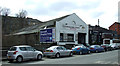
10
Crow Road railway station (site), Glasgow
Opened in 1896 by the Lanarkshire and Dumbartonshire Railway, part of the Caledonian Railway, on the line from Possil to Dumbarton via Whiteinch, this station closed in 1960.
View south towards Whiteinch and Dumbarton. The housing occupies the site and alignment of the platform. At the far end, the remains of the entrance building on a raft over the railway lines, as well as a short length of platform underneath, was still extant when this image was taken.
Image: © Nigel Thompson
Taken: 21 Feb 2019
0.07 miles