IMAGES TAKEN NEAR TO
Balshagray Drive, GLASGOW, G11 7DA
Introduction
This page details the photographs taken nearby to Balshagray Drive, G11 7DA by members of the Geograph project.
The Geograph project started in 2005 with the aim of publishing, organising and preserving representative images for every square kilometre of Great Britain, Ireland and the Isle of Man.

There are currently over 7.5m images from over14,400 individuals and you can help contribute to the project by visiting https://www.geograph.org.uk
Image Map
Images are licensed for reuse under creativecommons.org/licenses/by-sa/2.0
Notes
- Clicking on the map will re-center to the selected point.
- The higher the marker number, the further away the image location is from the centre of the postcode.
Image Listing (112 Images Found)
Images are licensed for reuse under creativecommons.org/licenses/by-sa/2.0
Image
Details
Distance
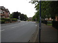
1
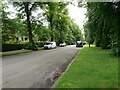
Balshagray Drive
A quiet residential street. It's hard to believe that there is a busy dual carriageway (Balshagray Avenue) just to the right on the other side of the row of trees.
Image: © Richard Sutcliffe
Taken: 12 Jul 2021
0.01 miles
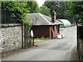
2
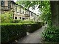
Houses, Balshagray Drive
A terrace of houses designed by John Burnet, Son & Campbell in 1888. They are all Category B listed http://portal.historicenvironment.scot/designation/LB32287.
Image: © Richard Sutcliffe
Taken: 12 Jul 2021
0.02 miles
3
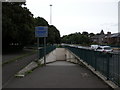
Subway under Balshagray Avenue
Pedestrian and cyclists' subway under the A739, Balshagray Avenue. It also leads to the cycle tunnel under the River Clyde.
Image: © Richard Sutcliffe
Taken: 9 Jul 2015
0.06 miles
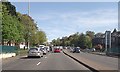
4
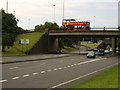
Busy road junction
Balshagray Road meets the Clydeside Expressway. Clyde Tunnel a little further along too. Note sign supporting Glasgow's Commonwealth Games bid.
Image: © Stephen Sweeney
Taken: 9 Aug 2007
0.08 miles
5
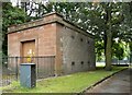
Electricity substation
Victoria Park Drive North substation.
Image: © Richard Sutcliffe
Taken: 12 Jul 2021
0.08 miles
7
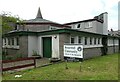
Broomhill Community Church of the Nazarene
At the corner of Broomhill Drive and Norby Road.
Image: © Richard Sutcliffe
Taken: 12 Jul 2021
0.09 miles
8
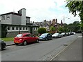
Norbury Road
Looking from Broomhill Drive.
Image: © Richard Sutcliffe
Taken: 12 Jul 2021
0.09 miles
9
Victoria Park Avenue North
Looking towards the traffic lights at Balshagray Avenue.
Image: © Richard Sutcliffe
Taken: 9 Jul 2015
0.09 miles
10
Partick Curling Club Pavilion
Arts and Crafts style curling pavilion, dating from 1900. It is Category C listed http://portal.historicenvironment.scot/designation/LB51588. Unfortunately it is situated in what is now the Parks Department depot for Victoria Park, so this was the best view I could get. The curling pond itself was situated a few metres to the southeast.
Image: © Richard Sutcliffe
Taken: 12 Jul 2021
0.09 miles