IMAGES TAKEN NEAR TO
Broomhill Drive, GLASGOW, G11 7AS
Introduction
This page details the photographs taken nearby to Broomhill Drive, G11 7AS by members of the Geograph project.
The Geograph project started in 2005 with the aim of publishing, organising and preserving representative images for every square kilometre of Great Britain, Ireland and the Isle of Man.

There are currently over 7.5m images from over14,400 individuals and you can help contribute to the project by visiting https://www.geograph.org.uk
Image Map
Images are licensed for reuse under creativecommons.org/licenses/by-sa/2.0
Notes
- Clicking on the map will re-center to the selected point.
- The higher the marker number, the further away the image location is from the centre of the postcode.
Image Listing (85 Images Found)
Images are licensed for reuse under creativecommons.org/licenses/by-sa/2.0
Image
Details
Distance
1
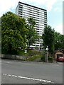
Tower block, Broomhill
One of two blocks on Broomhill Drive.
Image: © Richard Sutcliffe
Taken: 12 Jul 2021
0.05 miles
2
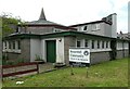
Broomhill Community Church of the Nazarene
At the corner of Broomhill Drive and Norby Road.
Image: © Richard Sutcliffe
Taken: 12 Jul 2021
0.06 miles
3
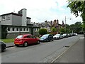
Norbury Road
Looking from Broomhill Drive.
Image: © Richard Sutcliffe
Taken: 12 Jul 2021
0.07 miles
4
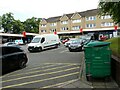
Broomhill Square
A selection of shops off Broomhill Drive.
Image: © Richard Sutcliffe
Taken: 12 Jul 2021
0.09 miles
5
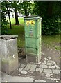
Electricity distribution box
A slender distribution box, beside Broomhill Drive. It bears the cast coat of arms of Glasgow Corporation and the letters: 'G.G.E.D.', standing for Glasgow Corporation Electricity Department. The current suppliers are SP Distribution. Compare this with other boxes Image, Image
Image: © Richard Sutcliffe
Taken: 12 Jul 2021
0.10 miles
6

View over Glasgow
The earlier clouds have disappeared, and Glasgow is bathed in sunshine. The row of Mossheights flats stand out on the left in the middle distance, along with other tower blocks including those at Broomhill, 13km away in the centre. There is snow on the Campsie Fells in the far distance. Seen from Caulders Braidbar Garden Centre Image
Image: © Richard Sutcliffe
Taken: 9 Jan 2020
0.10 miles
7
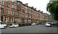
Red sandstone tenements
Along the north side of Broomhill Drive.
Image: © Richard Sutcliffe
Taken: 12 Jul 2021
0.11 miles
8
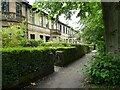
Houses, Balshagray Drive
A terrace of houses designed by John Burnet, Son & Campbell in 1888. They are all Category B listed http://portal.historicenvironment.scot/designation/LB32287.
Image: © Richard Sutcliffe
Taken: 12 Jul 2021
0.11 miles
9
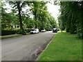
Balshagray Drive
A quiet residential street. It's hard to believe that there is a busy dual carriageway (Balshagray Avenue) just to the right on the other side of the row of trees.
Image: © Richard Sutcliffe
Taken: 12 Jul 2021
0.12 miles
10
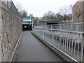
Pedestrian and cyclists' entrance to the Clyde Tunnel
One of two pedestrian entrances to the tunnel from the north (the one to the east of here is not open to cyclists).
Image: © Barbara Carr
Taken: 22 Apr 2013
0.12 miles