IMAGES TAKEN NEAR TO
Castlebank Place, GLASGOW, G11 6DS
Introduction
This page details the photographs taken nearby to Castlebank Place, G11 6DS by members of the Geograph project.
The Geograph project started in 2005 with the aim of publishing, organising and preserving representative images for every square kilometre of Great Britain, Ireland and the Isle of Man.

There are currently over 7.5m images from over14,400 individuals and you can help contribute to the project by visiting https://www.geograph.org.uk
Image Map
Images are licensed for reuse under creativecommons.org/licenses/by-sa/2.0
Notes
- Clicking on the map will re-center to the selected point.
- The higher the marker number, the further away the image location is from the centre of the postcode.
Image Listing (153 Images Found)
Images are licensed for reuse under creativecommons.org/licenses/by-sa/2.0
Image
Details
Distance
1
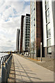
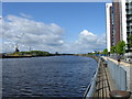
New Housing, former Meadowside Grain Terminal
Taken from river bus during a geography field trip
Image: © Jim Mcdougall
Taken: 2 Oct 2007
0.06 miles
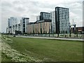
2
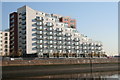
Glasgow Harbour Housing Development
New 'luxury' flats by the side of the River Clyde
Image: © Iain Thompson
Taken: 3 Nov 2006
0.06 miles
3
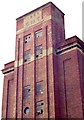
Meadowside Granary (the 1937 building)
This is the easternmost of a group of very imposing brick buildings that once stood on this site; it was built in 1937, and was demolished in 2002. The "CNT" stands for "Clyde Navigation Trust".
Image: © Lairich Rig
Taken: Unknown
0.06 miles
5

Partick West railway station (site), Glasgow
Opened in 1896 by the Lanarkshire and Dumbartonshire Railway, effectively part of the Caledonian Railway, on the line from Possil and Stobcross to Dumbarton via Partick, this station closed in 1964.
View north east towards Partick Central and Stobcross. The platforms were on a viaduct parallel to the road here, where the shrubbery now is.
Image: © Nigel Thompson
Taken: 29 Apr 2019
0.08 miles
7
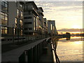
New Home
New dwellings spring up alongside the River Clyde after the demolition of the bonds and warehouses. Regeneration of the port.
Image: © Simon Johnston
Taken: 7 Jun 2007
0.09 miles
8
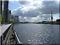
Glasgow Harbour and the Upper Clyde
Glasgow Harbour is to the right, BAE Govan Shipyard with Type 45 Destroyer D37 "Duncan" on the slips and Strathclyde Police boat "Pegasus" mid-stream.
Image: © Thomas Nugent
Taken: 25 Sep 2010
0.09 miles
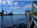
9
South Street
looking east toward the luxury flats... More construction can be seen on the right, as well as the cranes of Govan Shipyard across the river.
Image: © Darrin Antrobus
Taken: 22 May 2007
0.09 miles