IMAGES TAKEN NEAR TO
Fortrose Street, GLASGOW, G11 5NS
Introduction
This page details the photographs taken nearby to Fortrose Street, G11 5NS by members of the Geograph project.
The Geograph project started in 2005 with the aim of publishing, organising and preserving representative images for every square kilometre of Great Britain, Ireland and the Isle of Man.

There are currently over 7.5m images from over14,400 individuals and you can help contribute to the project by visiting https://www.geograph.org.uk
Image Map
Images are licensed for reuse under creativecommons.org/licenses/by-sa/2.0
Notes
- Clicking on the map will re-center to the selected point.
- The higher the marker number, the further away the image location is from the centre of the postcode.
Image Listing (346 Images Found)
Images are licensed for reuse under creativecommons.org/licenses/by-sa/2.0
Image
Details
Distance
1
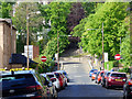
Fortrose Street
The scoreboard at West of Scotland Cricket Club can be seen on the left. Viewed from Dumbarton Road.
Image: © Thomas Nugent
Taken: 17 May 2019
0.02 miles
2
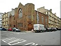
Glasgow Reformed Presbyterian Church
At the corner of Muirpark Street and Gardner Street.
Image: © Richard Sutcliffe
Taken: 29 Apr 2023
0.03 miles
3
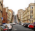
Gardner Street
Seen from Dumbarton Road.
Image: © Richard Sutcliffe
Taken: 10 Mar 2019
0.03 miles
4
Fiddlers Bar
Bar on Fortrose Street.
Image: © Richard Sutcliffe
Taken: 16 Aug 2018
0.04 miles
5

Sign for Fiddlers Bar
On Fortrose Street [http://www.geograph.org.uk/photo/5876240].
Image: © Richard Sutcliffe
Taken: 16 Aug 2018
0.04 miles
6
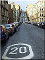
Gardner Street
Twenty's plenty, at the corner of Dumbarton Road.
Image: © Thomas Nugent
Taken: 21 Jan 2012
0.05 miles
7
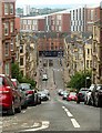
Gardner Street, Partickhill
Looking down towards Partick. This is the reverse view to https://www.geograph.org.uk/photo/6194991
Image: © Alan Murray-Rust
Taken: 25 Jun 2019
0.05 miles
8
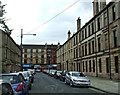
Fortrose Street
Looking towards Dumbarton Road from Burgh Hall Street. The building on the right is part of a Category B Listed tenement block http://data.historic-scotland.gov.uk/pls/htmldb/f?p=2200:15:0::::BUILDING:32861 which extends to Dumbarton Road and Peel Street.
Image: © Thomas Nugent
Taken: 10 Aug 2013
0.05 miles
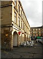
9
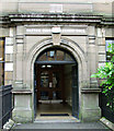
Partick Burgh Halls
A Category B Listed building http://data.historic-scotland.gov.uk/pls/htmldb/f?p=2200:15:0::::BUILDING:32852 by architect William Leiper in 1872. Located on Burgh Hall Street. This is the entrance to the lesser hall.
Image: © Thomas Nugent
Taken: 10 Aug 2013
0.05 miles
