IMAGES TAKEN NEAR TO
Church Street, GLASGOW, G11 5JT
Introduction
This page details the photographs taken nearby to Church Street, G11 5JT by members of the Geograph project.
The Geograph project started in 2005 with the aim of publishing, organising and preserving representative images for every square kilometre of Great Britain, Ireland and the Isle of Man.

There are currently over 7.5m images from over14,400 individuals and you can help contribute to the project by visiting https://www.geograph.org.uk
Image Map
Images are licensed for reuse under creativecommons.org/licenses/by-sa/2.0
Notes
- Clicking on the map will re-center to the selected point.
- The higher the marker number, the further away the image location is from the centre of the postcode.
Image Listing (566 Images Found)
Images are licensed for reuse under creativecommons.org/licenses/by-sa/2.0
Image
Details
Distance
1
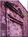
Bricked Up.
Old School entrance Torness Street
Image: © Lynn M Reid
Taken: 26 Mar 2008
0.00 miles
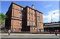
2
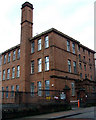
Former Church Street School
On Church Street, off Byres Road.
Image: © Thomas Nugent
Taken: 8 Dec 2012
0.01 miles
3
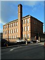
Former Church Street School
Category C listed http://portal.historicenvironment.scot/designation/LB48969 former school, dating from 1903. It closed as a school in 1976 and has more recently been used by the City's Health and Social Care Partnership.
Image: © Richard Sutcliffe
Taken: 24 Feb 2023
0.01 miles
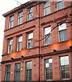
5
Former Church Street School
On Church Street, viewed from Byres Road, now home to Social Work Services. The former (now dilapidated) school swimming pool building can be seen on the right https://www.28dayslater.co.uk/threads/church-street-school-swimming-pool-glasgow-april-2018.113258/ .
See also Image
Image: © Thomas Nugent
Taken: 17 May 2019
0.02 miles
6
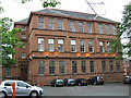
Former school
Former Govan Parish School Board Church Street Public School off Byres Road. Built in 1903, now appears to be flats.
Image: © Thomas Nugent
Taken: 12 Jul 2008
0.02 miles
7
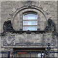
Portico, former Tennent Memorial Institute of Ophthalmology, Glasgow
The main entrance of the former Tennent Memorial Institute of Ophthalmology http://www.geograph.org.uk/photo/6198412 , opened in 1936 and moved in 1990. The building was used for other medical purposes until 2015 and is now awaiting redevelopment by the University of Glasgow. The two figures above the door, a sleeping girl and an awake boy, represent darkness and light https://www.universitystory.gla.ac.uk/building/?id=38 .
Image: © Rudi Winter
Taken: 26 Jun 2019
0.02 miles
8
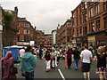
Byres Road, West End
Not normally pedestrianised - this photo was taken during the West End Festival, June 10th 2007.
Image: © Stephen Sweeney
Taken: 10 Jun 2007
0.02 miles
9
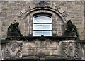
The Tennent Memorial Building
By architect Norman A Dick (Burnet Son and Dick) in 1935. The sculptor was A. Dawson. A B Listed building http://www.britishlistedbuildings.co.uk/sc-32856-38-church-street-10a-dumbarton-road-weste . See also Image & Image
Image: © Thomas Nugent
Taken: 8 Dec 2012
0.02 miles
10
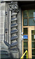
The Tennent Memorial Building
One of the barley-sugar door columns by architect Norman A Dick (Burnet Son and Dick) in 1935. The sculptor was A. Dawson. A B Listed building http://www.britishlistedbuildings.co.uk/sc-32856-38-church-street-10a-dumbarton-road-weste . Note the owl and mouse at the top of the column Image See also Image
Image: © Thomas Nugent
Taken: 8 Dec 2012
0.02 miles