IMAGES TAKEN NEAR TO
Ballam Road, LYTHAM ST. ANNES, FY8 4TS
Introduction
This page details the photographs taken nearby to Ballam Road, FY8 4TS by members of the Geograph project.
The Geograph project started in 2005 with the aim of publishing, organising and preserving representative images for every square kilometre of Great Britain, Ireland and the Isle of Man.

There are currently over 7.5m images from over14,400 individuals and you can help contribute to the project by visiting https://www.geograph.org.uk
Image Map
Images are licensed for reuse under creativecommons.org/licenses/by-sa/2.0
Notes
- Clicking on the map will re-center to the selected point.
- The higher the marker number, the further away the image location is from the centre of the postcode.
Image Listing (168 Images Found)
Images are licensed for reuse under creativecommons.org/licenses/by-sa/2.0
Image
Details
Distance
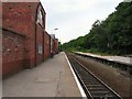
1
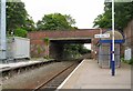
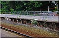
Lytham Station
Looking under Ballam Road bridge towards Preston. The line which originally ran to Blackpool Central now only carries an infrequent service to Blackpool South. A small shelter is provided on the end of the platform for waiting passengers. The originally station buildings have been converted to a tavern Image
Image: © Gerald England
Taken: 18 Jun 2013
0.08 miles
2
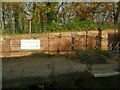
Lytham station, disused platform
In the heyday of holiday trains to the seaside, Lytham had two platforms, of which only one is now in use. The white notice on the wall explains that the planters, of which one is shown here, are to encourage biodiversity. See Image for context.
Image: © Stephen Craven
Taken: 17 Nov 2021
0.09 miles
4

New housing development at South Park April 2006
Image: © Keith Burroughs
Taken: 1 Apr 2006
0.09 miles
5
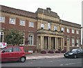
Top of Dicconson Terrace
A cold clear afternoon in February showing The Royal Bank of Scotland & the main shopping street.
Image: © N Houghton
Taken: 16 Feb 2008
0.09 miles
6
Crumbling disused platform at Lytham Railway Station, Station Square, Lytham
The railway line between Blackpool South and Preston, which runs through here, was reduced to single track in the early 1980's. This platform is no longer used and has started to deteriorate.
Image: © P L Chadwick
Taken: 1 Sep 2012
0.09 miles
7
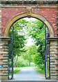
Lytham Hall gatehouse
This structure is the gatehouses (one on either side of the entrance way) marking the entrance on Ballam Road to Lytham Hall and its park. Lytham St Anne's, Lancashire.
Image: © Carroll Pierce
Taken: 6 May 2022
0.09 miles
8
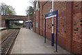
Lytham Station
Lytham is a stop on the Kirkham - Blackpool South branch with an hourly service each way. This was actually the second station in the town, opening in 1863 almost twenty years after the first station. For a few years the two stations operated independently but in 1874 a new connecting line was built which allowed the older station to be reduced to goods status only. This history has resulted in the oddity of Station Road not leading to the station.
Image: © Stephen McKay
Taken: 21 Apr 2012
0.09 miles
9
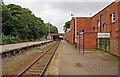
Lytham Railway Station looking east, Station Square, Lytham
The station is on the line from Preston to Blackpool South. In days past when visitors flocked to the Fylde Coast by train, the line used to be double track. Today it has been reduced to single track and only this platform is in use. The original station building is now a public house but there is a basic shelter near the bridge which serves as a waiting room. The bridge carries Ballam Road across the line. Photographed looking in the direction of Preston.
Image: © P L Chadwick
Taken: 1 Sep 2012
0.09 miles
10
Lytham Station
Although the station is still open with a single line to Blackpool South the former station buildings have been converted into a tavern Image
Image: © Gerald England
Taken: 18 Jun 2013
0.10 miles