IMAGES TAKEN NEAR TO
Northwood Close, LYTHAM ST. ANNES, FY8 4RG
Introduction
This page details the photographs taken nearby to Northwood Close, FY8 4RG by members of the Geograph project.
The Geograph project started in 2005 with the aim of publishing, organising and preserving representative images for every square kilometre of Great Britain, Ireland and the Isle of Man.

There are currently over 7.5m images from over14,400 individuals and you can help contribute to the project by visiting https://www.geograph.org.uk
Image Map
Images are licensed for reuse under creativecommons.org/licenses/by-sa/2.0
Notes
- Clicking on the map will re-center to the selected point.
- The higher the marker number, the further away the image location is from the centre of the postcode.
Image Listing (19 Images Found)
Images are licensed for reuse under creativecommons.org/licenses/by-sa/2.0
Image
Details
Distance
1
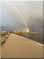
Rainbow from the Fairhaven Lake Coastal Defence Path
Whilst visiting friends, John and Val, we went for a walk along the recently upgraded Coastal Defence Path, which stretches from the Northern end of Fairhaven Lake to the start of Lytham Green ...
... and were delighted to see this fabulous Rainbow lighting the way.
Also, in the view is the distinctive Fairhaven United Reformed Church,
better known locally, and by the many visitors to this area, as The White Church
Image: © Terry Robinson
Taken: 10 Nov 2020
0.10 miles
3
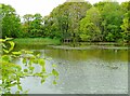
Curtains Pond
This is Curtains Pond, located to the south west of the grounds at Lytham Hall, Lytham St Anne's, Lancashire. I am standing on the east side of the pond and the housing estate off Forest Drive can be glimpsed through the treeline.
Image: © Carroll Pierce
Taken: 6 May 2022
0.14 miles
4
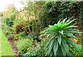
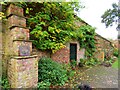
The Paradise Wall (3)
This is the Grade II listed Paradise Wall, Lytham Hall, Lytham St Anne's, Lancashire, seen around half way along and looking south towards the Mount. As can be seen here, the border is planted with an interested mix of plants and shrubs.
Image: © Carroll Pierce
Taken: 27 Oct 2022
0.20 miles
5
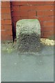
Old Milestone by the B5261, Blackpool Road, Ansdell
Carved stone post by the B5261, in parish of Lytham St Annes (Fylde District), Blackpool Road, Ansdell; by No. 9, by the road, on West side of road. Erected by the District Council in the 19th century.
Inscription once read:-
(Lytham)
(1)
Carved benchmark and rivet on top.
Milestone Society National ID: LA_LYBP02
Image: © J Higgins
Taken: 1 Jun 2009
0.20 miles
6
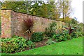
The Paradise Wall (1)
This is the Grade II listed Paradise Wall, Lytham Hall, Lytham St Anne's, Lancashire, as seen from its southern end. The border is planted with an interested mix of plants and shrubs including the banana tree to the right of shot.
Image: © Carroll Pierce
Taken: 27 Oct 2022
0.20 miles
7
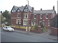
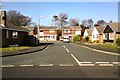
House in Lytham
Cambridge Rd/West Bank Ave. Looks much as it did in '67 - except that the little convenience store next door is gone.
Image: © Phil kemp
Taken: Unknown
0.20 miles
8
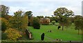
Lytham Hall from the Mount
I am atop The Mount, located in the grounds of Lytham Hall across the ornamental garden to the south of the house. The Mount was created in the 17th century using the soil excavated when digging Curtains Pond just to the west of the hillock.
Image: © Carroll Pierce
Taken: 27 Oct 2022
0.21 miles
9
The Paradise Wall (2)
This is the Grade II listed Paradise Wall, Lytham Hall, Lytham St Anne's, Lancashire, about half way along and looking north towards the Hall's kitchens.
Image: © Carroll Pierce
Taken: 27 Oct 2022
0.21 miles
10
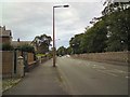
Church Road
The B5261 out of Lytham. At the junction up ahead it veers right as Blackpool Road with Cambridge Road going off to the left.
Image: © Gerald England
Taken: 16 Aug 2012
0.22 miles