IMAGES TAKEN NEAR TO
Wykeham Road, LYTHAM ST. ANNES, FY8 4JN
Introduction
This page details the photographs taken nearby to Wykeham Road, FY8 4JN by members of the Geograph project.
The Geograph project started in 2005 with the aim of publishing, organising and preserving representative images for every square kilometre of Great Britain, Ireland and the Isle of Man.

There are currently over 7.5m images from over14,400 individuals and you can help contribute to the project by visiting https://www.geograph.org.uk
Image Map
Images are licensed for reuse under creativecommons.org/licenses/by-sa/2.0
Notes
- Clicking on the map will re-center to the selected point.
- The higher the marker number, the further away the image location is from the centre of the postcode.
Image Listing (27 Images Found)
Images are licensed for reuse under creativecommons.org/licenses/by-sa/2.0
Image
Details
Distance
2
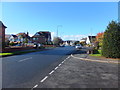
Mythop Road, Lytham
Residential street in the northern part of Lytham.
Image: © Barbara Carr
Taken: 4 Nov 2013
0.11 miles
3
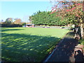
Bowling green, Lytham
On Mythop Road (the B5259).
Image: © Barbara Carr
Taken: 4 Nov 2013
0.16 miles


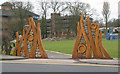
6
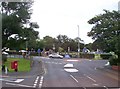
Children's recreation ground at Lytham
Viewed from end of Mythop Road
Image: © Raymond Knapman
Taken: 2 Aug 2012
0.18 miles
8
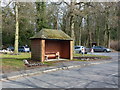
Bus Shelter
At the junction of Ballam Road and Park View Road, Lytham.
Image: © John H Darch
Taken: 21 Mar 2013
0.18 miles
9
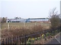
YMCA, Mythop Road, Lytham
Image: © Terry Robinson
Taken: 10 Apr 2013
0.18 miles
10
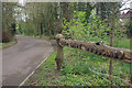
Green Drive Woodland
Green Drive was originally a driveway to Lytham Hall. It is now classed as an amenity woodland.
Image: © Stephen McKay
Taken: 21 Apr 2012
0.19 miles