IMAGES TAKEN NEAR TO
Curzon Road, LYTHAM ST. ANNES, FY8 3TE
Introduction
This page details the photographs taken nearby to Curzon Road, FY8 3TE by members of the Geograph project.
The Geograph project started in 2005 with the aim of publishing, organising and preserving representative images for every square kilometre of Great Britain, Ireland and the Isle of Man.

There are currently over 7.5m images from over14,400 individuals and you can help contribute to the project by visiting https://www.geograph.org.uk
Image Map
Images are licensed for reuse under creativecommons.org/licenses/by-sa/2.0
Notes
- Clicking on the map will re-center to the selected point.
- The higher the marker number, the further away the image location is from the centre of the postcode.
Image Listing (10 Images Found)
Images are licensed for reuse under creativecommons.org/licenses/by-sa/2.0
Image
Details
Distance
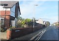
1
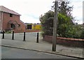
Lawrence Avenue
Access into Lawrence Avenue off Church Road is blocked by bollards.
Image: © Gerald England
Taken: 14 Aug 2012
0.07 miles
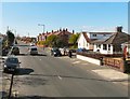
2
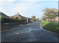
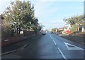
Winston Avenue
Residential street to the northeast of Church Road.
Image: © Barbara Carr
Taken: 20 Oct 2013
0.08 miles
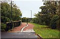
4
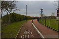
Cycleway past the Royal Lytham St Annes Golf Club
Image: © Ian Greig
Taken: 3 Apr 2018
0.19 miles
5
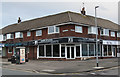
Shopping parade on the corner of Singleton Avenue and Shepherd Road
Image: © Ian Greig
Taken: 3 Apr 2018
0.20 miles
7
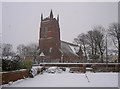
St Anne's Parish Church
The church in snow - very rare sight for this part of the world!
Image: © Jay
Taken: 12 Mar 2006
0.20 miles
9
Albert Road, St Anne's
Residential street to the northeast of the centre of St Anne's.
Image: © Barbara Carr
Taken: 20 Oct 2013
0.22 miles
10
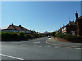
Church Road
From the end of Lyndsay Avenue.
Image: © Gerald England
Taken: 15 Apr 2012
0.24 miles