IMAGES TAKEN NEAR TO
Fieldway, LYTHAM ST. ANNES, FY8 3BL
Introduction
This page details the photographs taken nearby to Fieldway, FY8 3BL by members of the Geograph project.
The Geograph project started in 2005 with the aim of publishing, organising and preserving representative images for every square kilometre of Great Britain, Ireland and the Isle of Man.

There are currently over 7.5m images from over14,400 individuals and you can help contribute to the project by visiting https://www.geograph.org.uk
Image Map
Images are licensed for reuse under creativecommons.org/licenses/by-sa/2.0
Notes
- Clicking on the map will re-center to the selected point.
- The higher the marker number, the further away the image location is from the centre of the postcode.
Image Listing (6 Images Found)
Images are licensed for reuse under creativecommons.org/licenses/by-sa/2.0
Image
Details
Distance
1
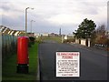
Leach Lane, St Annes
Leach Lane originally continued forward from here to meet St Annes Road, Blackpool but it was blocked at this point when the airfield was constructed during World War II. Note Blackpool Tower in the distance and "any persons ... is liable" on the sign.
Image: © Roger W Haworth
Taken: 27 Dec 2005
0.06 miles
2

Blackpool International Airport
Entrance for emergency vehicles
Image: © Ian Greig
Taken: 16 Apr 2018
0.17 miles

4
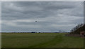
Planes taking off from Blackpool International Airport
Image: © Ian Greig
Taken: 16 Apr 2018
0.24 miles
5

Wind sock and radio mast, Blackpool Airfield
Image: © Peter Bond
Taken: 12 Jan 2012
0.24 miles
6
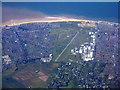
Blackpool International Airport
An aerial view from above the M55 as it crosses The Fylde.
Image: © M J Richardson
Taken: 26 Sep 2015
0.24 miles