IMAGES TAKEN NEAR TO
Redfern Way, LYTHAM ST. ANNES, FY8 2FN
Introduction
This page details the photographs taken nearby to Redfern Way, FY8 2FN by members of the Geograph project.
The Geograph project started in 2005 with the aim of publishing, organising and preserving representative images for every square kilometre of Great Britain, Ireland and the Isle of Man.

There are currently over 7.5m images from over14,400 individuals and you can help contribute to the project by visiting https://www.geograph.org.uk
Image Map
Images are licensed for reuse under creativecommons.org/licenses/by-sa/2.0
Notes
- Clicking on the map will re-center to the selected point.
- The higher the marker number, the further away the image location is from the centre of the postcode.
Image Listing (79 Images Found)
Images are licensed for reuse under creativecommons.org/licenses/by-sa/2.0
Image
Details
Distance
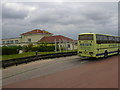
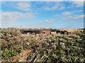
1
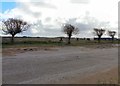
Site of Pontins Holiday Camp
The former Pontins Holiday Camp has been demolished and the site now lies derelict.
Image: © Gerald England
Taken: 10 Apr 2012
0.04 miles
2
Demolition work at Pontins
Demolition of the remaining buildings at the former holiday camp.
Image: © Gerald England
Taken: 27 Sep 2013
0.06 miles
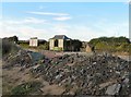
3
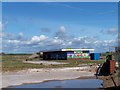
Derelict building on the site of the former Pontins Blackpool
I think this was the camp shop ... and at the time of posting is still in the section of the site awaiting demolition. Everything to its left has been demolished. Image Image Image Image Image
Image: © Terry Robinson
Taken: 16 May 2012
0.06 miles
4
Pontins long gone
The site of the former holiday camp.
Image: © Gerald England
Taken: 27 Sep 2013
0.06 miles
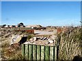
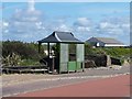
6
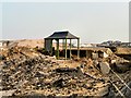
Bus Shelter at Pontins
Abandoned bus shelter on the mostly-demolished site of Pontins Holiday Camp.
Image: © Gerald England
Taken: 10 Apr 2013
0.07 miles
7
Pontins Bus Terminus
The line#1 bus from Fleetwood used to turn round here at the entrance to Pontins Holiday Camp. The camp was closed in 2009 and has been partially demolished. The bus layby has been closed off. The #1 bus now terminates at Starr Gate. The bus shelter is slowly decaying.
Image: © Gerald England
Taken: 18 Aug 2012
0.07 miles
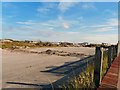
8
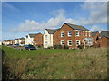
New housing development at Squires Gate, near St. Anne's-on-the-Sea
A newly-built housing development at Squires Gate, near the coastal towns of St. Anne's-on-the-Sea and Blackpool.
Image: © Malc McDonald
Taken: 10 Oct 2021
0.08 miles
9
Bus Shelter at the entrance to the former site of Pontins Blackpool
Pictures of this bus shelter showing Buses at this stop are shown in the Fylde Bus Blog site ... http://fyldebus.blogspot.co.uk/ ... put Pontins in the search box - picture nine shows the shelter and the rear of the 'triangular' site sign shown on some linked views ... See also ... Image Image Image Image Image
Image: © Terry Robinson
Taken: 16 May 2012
0.08 miles
10
Site of Pontins Holiday Camp
The buildings of Blackpool Airport are in the background.
Image: © Gerald England
Taken: 7 Mar 2014
0.08 miles