IMAGES TAKEN NEAR TO
Mayfield Road, LYTHAM ST. ANNES, FY8 2DP
Introduction
This page details the photographs taken nearby to Mayfield Road, FY8 2DP by members of the Geograph project.
The Geograph project started in 2005 with the aim of publishing, organising and preserving representative images for every square kilometre of Great Britain, Ireland and the Isle of Man.

There are currently over 7.5m images from over14,400 individuals and you can help contribute to the project by visiting https://www.geograph.org.uk
Image Map
Images are licensed for reuse under creativecommons.org/licenses/by-sa/2.0
Notes
- Clicking on the map will re-center to the selected point.
- The higher the marker number, the further away the image location is from the centre of the postcode.
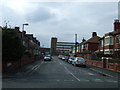
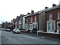
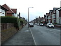
Image Listing (12 Images Found)
Images are licensed for reuse under creativecommons.org/licenses/by-sa/2.0
Image
Details
Distance
2
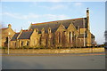
The Church of Our Lady of the Sea, St Annes on Sea
Image: © Alexander P Kapp
Taken: 15 Mar 2006
0.17 miles
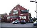
5
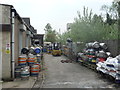
Lytham Brewery
Lytham Brewery, Cambells Court, Lord St, St. Annes. http://www.lythambrewery.co.uk/ Just a typical, independent micro-brewery.
Image: © Roger W Haworth
Taken: 24 Apr 2019
0.20 miles
9
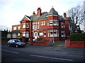
Headroomgate Nursing Home, St Annes-on-Sea
Image: © Alexander P Kapp
Taken: 11 Dec 2007
0.22 miles
10
St Annes Parish Church, Parish Rooms
Image: © Alexander P Kapp
Taken: 11 Dec 2007
0.23 miles