IMAGES TAKEN NEAR TO
Denford Avenue, LYTHAM ST. ANNES, FY8 1EJ
Introduction
This page details the photographs taken nearby to Denford Avenue, FY8 1EJ by members of the Geograph project.
The Geograph project started in 2005 with the aim of publishing, organising and preserving representative images for every square kilometre of Great Britain, Ireland and the Isle of Man.

There are currently over 7.5m images from over14,400 individuals and you can help contribute to the project by visiting https://www.geograph.org.uk
Image Map
Images are licensed for reuse under creativecommons.org/licenses/by-sa/2.0
Notes
- Clicking on the map will re-center to the selected point.
- The higher the marker number, the further away the image location is from the centre of the postcode.
Image Listing (25 Images Found)
Images are licensed for reuse under creativecommons.org/licenses/by-sa/2.0
Image
Details
Distance
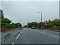
6
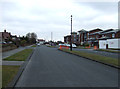
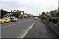
A584, Clifton Drive South, Lytham St Anne's
After running along the coast at Lytham the A584 moves inland passing through St Anne’s as Clifton Drive a wide Victorian-era road.
Image: © David Dixon
Taken: 22 Apr 2019
0.12 miles
8
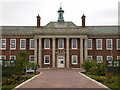
Formerly Queen Mary's Grammar School, Entrance
In the process of being converted into apartments
Image: © Alexander P Kapp
Taken: 11 Mar 2009
0.18 miles
10
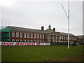
Formerly Queen Mary's Grammar School
Being converted into apartments
Image: © Alexander P Kapp
Taken: 11 Mar 2009
0.18 miles