IMAGES TAKEN NEAR TO
The Strand, FLEETWOOD, FY7 8NR
Introduction
This page details the photographs taken nearby to The Strand, FY7 8NR by members of the Geograph project.
The Geograph project started in 2005 with the aim of publishing, organising and preserving representative images for every square kilometre of Great Britain, Ireland and the Isle of Man.

There are currently over 7.5m images from over14,400 individuals and you can help contribute to the project by visiting https://www.geograph.org.uk
Image Map
Images are licensed for reuse under creativecommons.org/licenses/by-sa/2.0
Notes
- Clicking on the map will re-center to the selected point.
- The higher the marker number, the further away the image location is from the centre of the postcode.
Image Listing (5 Images Found)
Images are licensed for reuse under creativecommons.org/licenses/by-sa/2.0
Image
Details
Distance
3
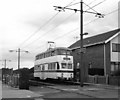
Tram at Rossall Square
'Balloon' car No 712 is northbound. This car is still in regular use at Blackpool.
Image: © Dr Neil Clifton
Taken: 28 Aug 1984
0.22 miles
4
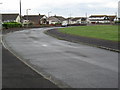
Roundway, Larkholme
Like most of the land near the seashore here, Larkholme is flat and devoid of trees of any size. The soil is shallow and often underlain by a hard layer of clay, making drainage and cultivation challenging.
Image: © Tony Fisher
Taken: 9 Jun 2010
0.24 miles
5
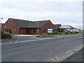
Rossall Hospital
Rossall Hospital rehabilitation unit on West Way.
Image: © David Dixon
Taken: 15 Jul 2012
0.25 miles