IMAGES TAKEN NEAR TO
Lothian Avenue, FLEETWOOD, FY7 8BY
Introduction
This page details the photographs taken nearby to Lothian Avenue, FY7 8BY by members of the Geograph project.
The Geograph project started in 2005 with the aim of publishing, organising and preserving representative images for every square kilometre of Great Britain, Ireland and the Isle of Man.

There are currently over 7.5m images from over14,400 individuals and you can help contribute to the project by visiting https://www.geograph.org.uk
Image Map
Images are licensed for reuse under creativecommons.org/licenses/by-sa/2.0
Notes
- Clicking on the map will re-center to the selected point.
- The higher the marker number, the further away the image location is from the centre of the postcode.
Image Listing (12 Images Found)
Images are licensed for reuse under creativecommons.org/licenses/by-sa/2.0
Image
Details
Distance
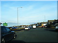
1
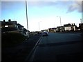
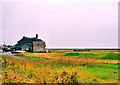
Princes Way. Fleetwood.
The building on the left is the golf clubhouse
Image: © James Denham
Taken: 27 Oct 2008
0.14 miles
2
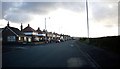
Princes Way, Fleetwood.
From near the golf course.
Image: © James Denham
Taken: 27 Oct 2008
0.14 miles
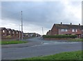
6
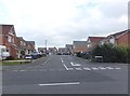
Kingfisher Way, Fleetwood
Residential street to the east of Beach Road.
Image: © Barbara Carr
Taken: 25 Oct 2013
0.21 miles
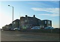
7
Fleetwood Golf Course
A links course hemmed in by houses and the sea defences.
Image: © Mike and Kirsty Grundy
Taken: 23 Aug 2005
0.21 miles
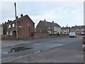
8
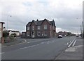
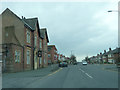
Beach Road, Fleetwood
With "Queens" public house at the junction with Poulton Road.
Image: © Barbara Carr
Taken: 25 Oct 2013
0.22 miles