IMAGES TAKEN NEAR TO
Homestead Way, FLEETWOOD, FY7 7NG
Introduction
This page details the photographs taken nearby to Homestead Way, FY7 7NG by members of the Geograph project.
The Geograph project started in 2005 with the aim of publishing, organising and preserving representative images for every square kilometre of Great Britain, Ireland and the Isle of Man.

There are currently over 7.5m images from over14,400 individuals and you can help contribute to the project by visiting https://www.geograph.org.uk
Image Map
Images are licensed for reuse under creativecommons.org/licenses/by-sa/2.0
Notes
- Clicking on the map will re-center to the selected point.
- The higher the marker number, the further away the image location is from the centre of the postcode.
Image Listing (6 Images Found)
Images are licensed for reuse under creativecommons.org/licenses/by-sa/2.0
Image
Details
Distance
1
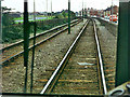
View from back of tram, 1975
The tram is heading for Fleetwood on reserved track with Radcliffe Road on the right and Copse Road on the left.
Image: © Robin Webster
Taken: Unknown
0.14 miles
2
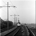
Approaching Larkholme Lane – 1973
Railcar 636 is returning from Fleetwood to Manchester Square and depot. The land between the tramway and Copse Road to the right has since been developed with industrial units.
Image: © Alan Murray-Rust
Taken: 17 Feb 1973
0.14 miles
3
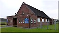
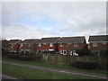
St Edmund Of Canterbury Church, Fleetwood
St Edmund Of Canterbury Church was founded in 1952 and it does not have a graveyard.
Image: © Rude Health
Taken: 20 Apr 2014
0.21 miles
4
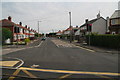
Larkholme Avenue, crossed by the Blackpool and Fleetwood Tramway
Image: © Chris
Taken: 31 Jul 2014
0.22 miles
6
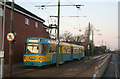
Passing Broadwater
These 'Progress twinsets' were conceived as an alternative to double-deck trams for moving large crowds.
This was a chartered trip, and may well be the last time one of these sets operated to Fleetwood.
Image: © Alan Murray-Rust
Taken: 8 Nov 2009
0.25 miles